

Prevention And Preparedness To Meet Mud Floods And Flooding In The River Basin Santa DWG Full Project for AutoCAD
THIS IS THE IDENTIFICATION OF AREAS OF RISK IN THE AREA OF SAN MATEO HUAROCHIRI DISTRICT IN THE RIVER BASIN TO PROJECT WORKS RIMAC afforestation SAME
Drawing labels, details, and other text information extracted from the CAD file (Translated from Spanish):
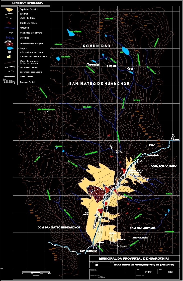
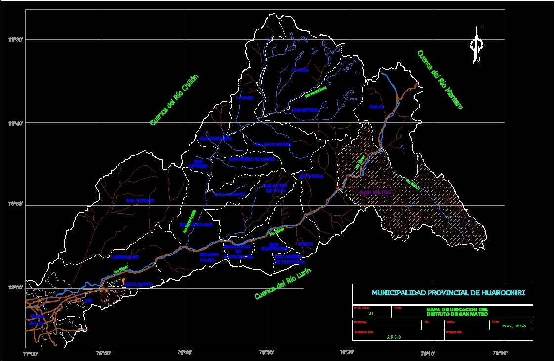
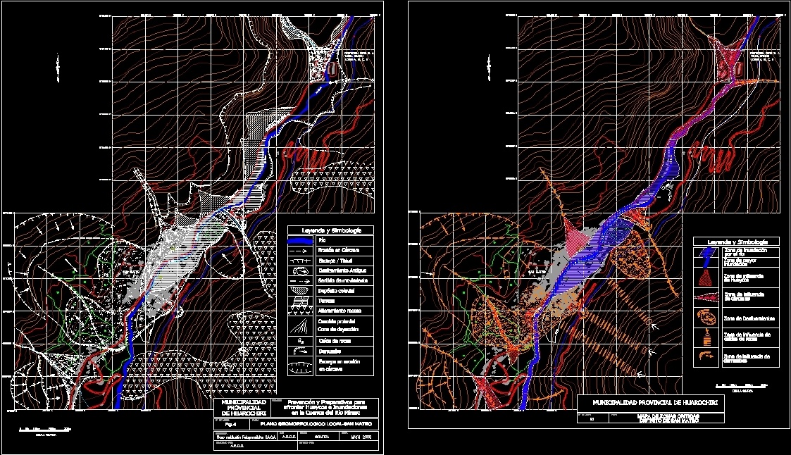
predes, center of studies and, prevention of disasters, project, prevention of huaycos and floods, in the rímac river basin, plane, map – seismic zones of Peru, scale, elaborated by :, revised by :, ingº juvenal medina, ingº alberto martínez vargas, sheet number, reference, date, graph, cad, rmm, national regulations of buildings, seismic prevention in, san juan de lurigancho, prevention and preparations for, facing huaycos and floods, plane of vulnerability, corcona and carachacra, graphic scale, movement for peace, san mateo, rimac river, central highway, north, fence, fence, tunnel graton, centromin peru s. a., lots a, b, c, d, legend and symbology, river, gully erosion, old landslide, direction of movement, colluvial deposit, terrace, rocky outcrop, pruvial cone, dejection cone, rock fall, landslide, Escarpment in erosion, in gully, landslide zone, major zone, flood zone, river, flood, zone of influence, huaycos, gully, zone of influence of, rock falls, landslides, local geomorphological map san mateo, arcc, photogrammetric restitution oaca, provincial municipality of huarochiri, map of critical areas, district of san mateo, municipality, provincial, huarochiri, river basin lurin, mantaro river basin, river basin chillón, matucana, san , antonio, san pedro de casta, san juan de iris, huachupampa, carampoma, otao, callahuanca, laraos, huanza, chilca, bartolome, groove, san andres, tupicocha, santa cruz, cocachacra, ricardo, palma, santa eulalia, san antonio, luriga ncho, chaclacayo, ate, city, lima, river rímac, ricardo palm, santa eulalia, san mateo de orao, callahuanca, san juan de lanca, matucana, san mateo, chicla, huanza, carampoma, laraos, san juan, iris , of huachupampa, san lorenzo, san pedro de casta, chaclla, chaclacayo, chosica, holy river eulalia, macochaca river, white river, groove, san bartolomé, location map, arcc, treatment of the rimac river channel, which crosses the city of san mateo, prevention and attenuation against flood, height of, walls, recommendation :, – must be permanent, – fine the amount of rubbish and dismount inside the river bed, – join the blocks with mortar., – waterproof the pircas., – do not use gabions in the lower part, – make the shoelace, – take advantage of pearl experience of the sun, in the lateral scouring:, scour, maximum, minimum, trash, concrete wall, street, road, central, housing, wall, – after increasing the height of the walls and build a bridge p metallic food with two pedestrian stairs, – this does not eliminate the disaster due to flooding of the collapse of the yuracmayo dam and also the future discharges during the climate crisis season. for the evaluation of vulnerability the lower part is very high vulnerability., _______, footwear, wedges wedges, calzaduras, model i, evaluation, in the city of Lima, legend, type, very high, high, medium, low, levels , level, critical, safe, more secure, zones, iii, color, com. san antonio, sector moya, dist. san mateo, com. san mateo de huanchor, c o m u n a d d, s a n m a t e o n h u a n c h o r, qda. parac, qda. uranmayac, tamboraque, uramayoc, fundo mayuco, centromin peru, cº sarayoc, c tipishash, centromin peru s.a., cº arara, puente infiernillo, cacray, qda. chamullay, qda. piscapuquio, cº jocohuanca, lag. urpo, cº pulihua, sign hill yana yana, qda. tango, qda. turumanya, qda. ucupampa, cº pisha, qda. rano, cº chichicocha, lag. ice cream, cº carbon runta, ice cream, cº jerusalen, qda. quiet, lag. paticocha, lag. shorca, cº snowed, cº carhuaranra, sacococha, chucllapampa, cº quecapunta, map risk zones district of san mateo, legend and symbolism, escarpment, flow line, arroyada, slope of land, gullies, ancient landslide, lagoon, water outcrop , qda. dasa, qda. huarca, tim-cf, q-g, colluvial deposit, summit line, secondary road, railway line, fluvial terrace, watershed limit, mine tailings court, provincial huarochiri municipality
Raw text data extracted from CAD file:
| Language | Spanish |
| Drawing Type | Full Project |
| Category | City Plans |
| Additional Screenshots |
   |
| File Type | dwg |
| Materials | Concrete, Other |
| Measurement Units | Metric |
| Footprint Area | |
| Building Features | |
| Tags | area, areas, autocad, basin, beabsicht, borough level, district, DWG, full, meet, mud, political map, politische landkarte, prevention, Project, proposed urban, river, road design, san, santa, stadtplanung, straßenplanung, urban design, urban plan, zoning |