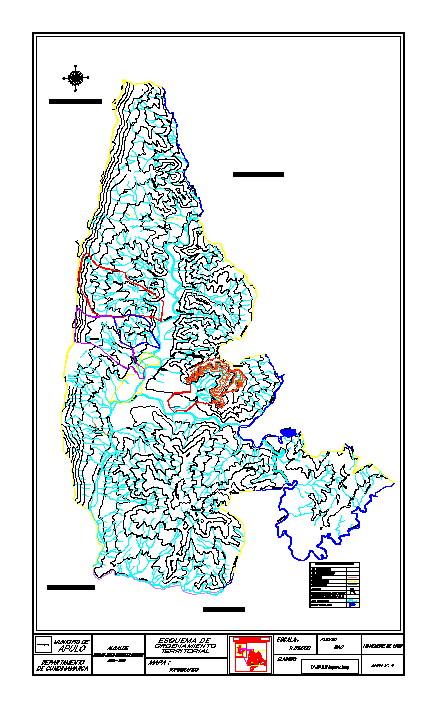
CuencL Palms location for aqueducts
Drawing labels, details, and other text information extracted from the CAD file (Translated from Spanish):
santafe de bogota dc, geographical location, republic of colombia, department of cundinamarca, junin, municipality of tocaima, municipality of viota, municipality of anapoima, mayor, jose de jesus monsalve soriano, apulo, municipality of, department, cundinamarca, territorial, ordination, outline, map:, political division, elaborate :, municipality of jerusalem, general conventions, river, creek, bridge, railway, property boundary, path, unpaved road, paved road, lagoon, scale:., source :, ingeominas-car, consultoria, q on saturday, rio bogota, q camargo, q of the refuge, q naranjal, q long puddle, q narcissus, rio apulo, q tropezon, lagoon salcedo, q stony, cotton, q the yeguera, q the cerro, q honda, q aposentos, hill of, aposentos, hill of the guacamayas, union, high, palenque, high of copial, cordillera de algodones, q. the salt, q. the thunder, sugar bread, hill of pita, hill of bejucal, hill of thunder, q. the lotu, q. tasajera, q. of the hawthorn, q. cachimbole, q. fields, calandaima, river, q. cake, q. of the, flowers, rio calandaima, q. the torcaza, topografico, bodies of water, igac