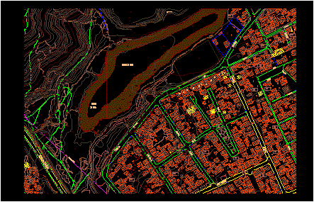
2D urban plan and topographic map of the Laguna Lo Galindo area in Concepción, Chile. This drawing provides a detailed urban trace of the neighborhood, featuring street names such as Avenida Alonso de Rivera, Manuel Gutierrez, and San Pablo. The layout includes lot boundaries with individual numbering and shaded building footprints.
The file contains site-specific technical data, including topographic contour lines with elevation labels, designated green areas (áreas verdes), and the primary body of water. Infrastructure elements like the high-voltage line (línea de alta tensión) are also indicated. The drawing is formatted for a 70 x 45 cm sheet at a scale of 1:1000. It is suitable for urban planning, site analysis, and regional mapping projects. Urbanismo en Concepción.