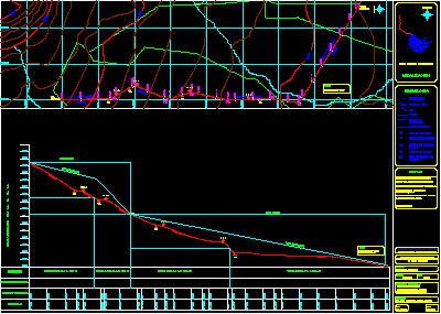
Project supplay potable water by gravedad from Purandiro municipality – Michoacan
Drawing labels, details, and other text information extracted from the CAD file (Translated from Spanish):
Notes, north, gap, gap, Driving line, location, Symbology, Cadence, River, gap, driving, Cline of, Plot boundary, Level curve, Catchment work, Regularizer tank, municipality:, Michoacan, country:, Mexico, Michoacan, state:, team members, Ventura huerta diego armando, date:, Supervision, Ing. Jose luis de la fuente severino, Trinidad garzon gabriel, Hernandez paloblanco antonio, key:, Topographical elevation, mileage, Driving line, New progress, Surface tank, Capturing box, pi., National Polytechnic Institute, Upper level of engineering architecture, Topographic plane of the line of conduction by gravity of the population of new progress, The azimuth of the line from the pickup box to the first inflection point is:, Total length of the line of gravity:, Highest elevation of population: m. S. N. M., Elevation of the tanqur: m. S. N. M. Tank height: m., Elevation of the catchment: m. S. N. M., M. S. N. M: meters above sea level, north, Elevations in m. S. N. M., Esc. Horizontal: esc. vertical:, profile, Esc. horizontal:, plant, classification, Piezometric elevation, V. D., V. and. to., Expulsion valve, Drain valve, of air, V. D., V. and. to., V. D., Regulator box, C. R., Pressure, A. C. Diam., Piezometric line, Static line, Piezometric line, to. C. Cement asbestos pipe