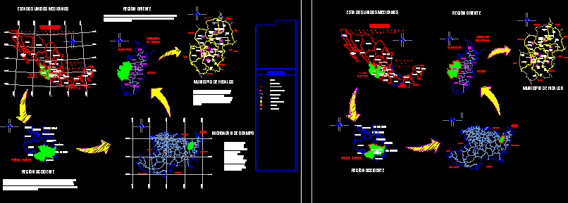
Mexico Map
Drawing labels, details, and other text information extracted from the CAD file (Translated from Spanish):
western, geographic Mexican region that extends by part of the coastal plain of the pacific ocean, the western mother mountain range, the volcanic axis, the basin of the rafts and the mother mountain range of the south, as well as by the southwest of the Mexican high plateau. formed by the states of nayarit, jalisco, colima and michoacán de ocampo, bordered on the north by sinaloa, durango and zacatecas, east by aguascalientes, guanajuato and mexico, south by warrior, and west by the pacific ocean., aguascalientes, guanajuato, ocampo, michoacán, colima, jalisco, nayarit, zacatecas, warrior, querétaro, edo. from mexico, durango, united states mexicans, western region, san luis potosi, michoacán de ocampo, maravatio, zinapecuaro, moths, the sulfurs, rincon de, blond, san matias, the big, houses, pints, querendaro, city, hidalgo, irimbo, san pedro, jacuaro, san nicolas, dry sticks, huajumbaro, the scree, cross of, roads, san bartolo, cuitareo, huaniqueo, tuxpan, el chaparro, benito, juarez, the mine, pucuato, the caracol, puerto, el leon, jose maria, morelos, mata de, pines, the nettle, los, agostitllan, ajolotes, cuitzillo, antonio, san, villalongin, colorada, tierra, tepozanes, the, jewels, jungapeo, bridge, hill, blue, tuzantla, el shipyard, san jose, pacific ocean, edo.de.mexico, queretaro, arteaga, huerta, zitacuaro, mexico, susupuato, senguio, tlalpujauha, contepec, angangueo, aporo, epitacio, eastern region, municipality of hidalgo, pacific ocean, pacific , oaxaca, puebla, chiapas, tehuantepec, gulf, tabasco, guatemala, belize, dea merica, unites states, tlaxcala, veracruz, oceano, california, south, baja, sinaloa, michoacan, df, coahuila, tamaulipas, new leon, sonora, chihuahua, mexican republic, mexico, de, campeche, roo, quintana, yucatan, gulf, tzitzio, symbolism, localities, holdings, geostatistical key, municipal limit, urban zone, municipal seat, state limit, border limit, coast, orientation, location