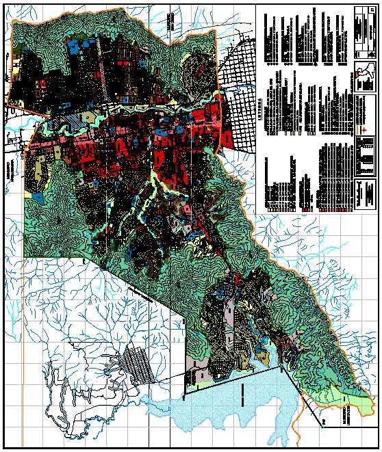
Mao San Jose, Venezuela–Urban Management Plan DWG Plan for AutoCAD
Urban Management Plan of San Jose City, Valencia, Carabobo State, Venezuela
Drawing labels, details, and other text information extracted from the CAD file (Translated from Spanish):
urban polygonal parish boundary, local urban development plan parish san jose, apv casupo, apv la guacamaya, apv hill the wheat, area under review, zup, apv, general, existing, primary, general, intermediate, primary, proposed, urban equipment, intermediate, eg ee, hey, ep ee, eg ep, hey, and, ep ep, educational, eg rde, hey, ep rde, eg rdp, hey rp, ep rdp, and mother, hey mom, and mother, eg map, hey map, ep map, eg sce, hey, ep ece, eg scp, hey scp, ep scp, eg age, hey age, eg agp, hey agp, medical practitioner, recreational sports, cultural partner, government administrative, existing, proposed, structure for special services, eg ce, eg cp, cemetery, eg pte, eg ptp, eg eae, eg eap, eg ptabe, eg ptabp, water ponds, sewage treatment plants, water treatment plant, eg ebe, eg ebp, pumping stations, eg seee, eg cte, eg ctp, eg ttae, telephonic central, Electrical substations, air terminal, eg mme, eg mmp, eg seep, land transport terminal, municipal market, eg ttap, eg ttte, eg tttp, security defense, municipal slaughterhouse, and me, eg mp, eg sde, eg sdp, simbology for the representation of the services urban equipment, Bolivarian republic of venezuela of the municipal municipality urban planning carabobo, department of urban planning, symbology for the representation of the road, nomenclature., traced, proposed road, urban polygonal, sector boundary, special plan delimitation, dpe, express, exp, arterial, art, collector, cabbage, main location, loc, zup, north guataparo avenue, street guacamaya, avenue guataparo south, avenue guataparo east, avenue tamanaco, street guataparo hills, golf avenue, street los caracas, street the mangoes, street el amparo, avenue la garza, avenue the deer, avenue paseo cuatricentenario, Street, avenue, Street, avenue, Street, avenue paseo cuatricentenario calle, Street, mujica alley, avenue eloy white, street water white, Street, street g. White, Street, north bolivar avenue, red street queipo, santa cecilia street, caribean street, Street, qda. the indigo, Street, avenue, Street, rio orinoco street, rio rio apure, rio portuguasa street, rio caroni street, calle rio chama, Street, avenue, Street, avenue, Street, avenue, Street, avenue, Street, avenue, Street, cedeño street, urdaneta street, calle marino, street sucre, san felix avenue, boyaca avenue, avenue monseñor adam, Street, avenue, Street, main Street, Street, avenue, uslar street, street pichincha, uslar street, Street, avenue, Street, street paez, street prebo, street los sauces, Street, avenue, qda. the indigo, Street, rio cabriales, Street, avenue victoria, Street, north bolivar avenue, avenue, Street, north bolivar avenue, Street, avenue, Street, east freeway, autocinema street, avenue mañongo, peaceful avenue, avenue mañongo, peaceful avenue, avenue arturo michelena, avenue, wheat street, avenue, Street, avenue, Street, motorway valencia pto. hair, avenue cabriales, Street, street flowers, avenue carabobo, avenue fernando figueredo, avenue cedeño, street salom, avenue, capricorn street, Sagittarian street, scorpion street, street leo, street libra, pisces street, Street, avenue, street geminis, street pluton, calle apolo, street nept
Raw text data extracted from CAD file:
| Language | Spanish |
| Drawing Type | Plan |
| Category | City Plans |
| Additional Screenshots |
 |
| File Type | dwg |
| Materials | Other |
| Measurement Units | |
| Footprint Area | |
| Building Features | Car Parking Lot |
| Tags | autocad, beabsicht, borough level, city, DWG, jose, management, plan, political map, politische landkarte, proposed urban, road design, san, stadtplanung, state, straßenplanung, urban, urban design, urban plan, valencia, Venezuela, zoning |
