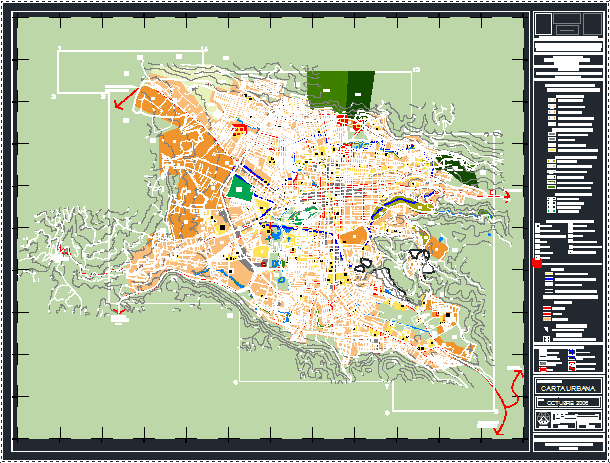
Map San Cristobal, Chiapas, Mexico DWG Block for AutoCAD
Urban Charter of San Cristobal Chiapas
Drawing labels, details, and other text information extracted from the CAD file (Translated from Spanish):
conventional symbols, uses and primary zoning, industrial and services, mixed uses, extractive industry, preservation uses, agricultural, ecological conservation, ecological reserve, proposal of ecological reserve, urban structure, urban center., urban sub-center, neighborhood center, rec, equipment destinations., limits, historic center limit, buffer zone limit., current urban area., extractive industry limit., infrastructure destinations., regional. , primary, pedestrian, roads, electrical substation, electric power, sewerage, eastern electric substation, san cristobal electric substation, education, central load, public administration, health, religion, recreation, culture ., urban park., the equipments that appear with red frame are proposed., neighborhood of san antonio, neighborhood of santa lucia, neighborhood of guadeloupe, neighborhood of cuxtitali, neighborhood of tlaxcala, the reliquary, neighborhood san ramon, col. erasto urbina, fracc. san juan de los Lagos, peje de oro, san felipe ecatepec, el carmen esplanade, fracc. bismark, col. the ant, fracc. america libre, neighborhood the sanctuary, the guadeloupe carmen, neighborhood tepeyac, the border, san nicolas, fracc. the race, col. maya, col. prudencio moscoso, maria auxiliadora neighborhood, mexican district, downtown district, c edgar robledo., diagonal frans blom., c. real de guadalupe., c. francisco i wood., c. felipe flores., c. guadeloupe victoria., c. Diego de Mazariegos., c. francisco leon .., c. pacheco luna., roadway of youth., south peripheric., diagonal ramon larrainzar, international highway., west periphery., north periphery., tlaxcala road, c. dr navarro., av. Miguel Hidalgo. Insurgentes., c.j. ma morelos., road axis., neighborhood of san diego, district of la merced, calzada mexico., calzada salomon gonzalez., c. ignacio allende., col. the island, fracc. lomas de huitepec, fracc. real del monte, to san juan chamula and zinacantan., to tuxtla gutierrez., to comitán de dominguez., to tenejapa, neighborhood eye of water., urban layout, limit current urban area, perennial waters, intermittent waters and canals, bridge, secretary, date, name of the map, graphic scale, north, ada gricelda bonifaz villar, secretariat of public works and housing, municipal president, lic. sergio lobato garcía, h. municipal council, constitutional governor of the state, pablo salazar mendiguchía, urban charter, scale :, meters, dimension:, main roads, dirt roads, fee, free, reserves for growth., rh, san cristobal de las casas – chiapas, moxviquil , gertrudis duby, gas gas station, aguilar gas station, olin highway gas station, gas station, olin gas station, gas gas station -com, huitepec gas station, san juan gas station, chiapas state government, la garita road, col. san antonio del monte, towards the drainage tunnel, urban equipment area, cemetery., public safety., sport., bus terminal., supply, market, trail., gasoliniera-gas, san cristobal hill, prec, green areas of preservation., intercultural university
Raw text data extracted from CAD file:
| Language | Spanish |
| Drawing Type | Block |
| Category | City Plans |
| Additional Screenshots |
 |
| File Type | dwg |
| Materials | Wood, Other |
| Measurement Units | Metric |
| Footprint Area | |
| Building Features | Garden / Park |
| Tags | autocad, beabsicht, block, borough level, charter, chiapas, cristobal, DWG, map, mexico, political map, politische landkarte, proposed urban, road design, san, stadtplanung, straßenplanung, urban, urban design, urban plan, zoning |
