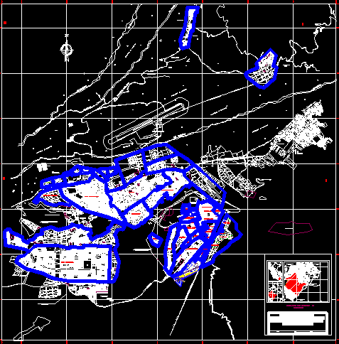
Map Of Moquegua, Peru DWG Block for AutoCAD
Moquegua map
Drawing labels, details, and other text information extracted from the CAD file (Translated from Spanish):
market, street igualgua, Related searches, avenue andres avelino caceres, Mayta Capac, public alley, street tupac yupanqui, cahuide street, passage, alley, public, huayna capac street, street igualgua, avenue andres avelino caceres, street igualgua, huayna capac street, Street, jose olaya avenue, street mayta capac, November street, pasaje santo miguel arcangel, passage, ticket, pje sta fortunata, future passage, passage los angeles, jose olaya passage, passage the winners, street tahuantinsuyo, pje sta fortunata, passage san juan bautista, from cheers, pje sn martín, passage, passage, street huascar, passage, street tupac yupanqui, avenue emancipation, Street, san antonio extension, street the cover, passage daniel becerra or., passage, san pedro ticket, passage c ‘, passage the union, passage joy, square, Inca rock passage, Koya Passage, November street, pastry, passage peru, pass the stars, street immaculate conception, passage, santa rosa de lima street, pje sto miguel arcangel, pje sto toribio de padua, Street, passage tupac amaru, passage the proceres, Street, street c ‘, passage, san antonio ticket, street tahuantinsuyo, street tupac amaru, avenue the incas, street huascar, cahuide street, street tupac yupanqui, los angeles street, calle atahualpa, huayna capac street, street misti, street cesar vallejo, street jose carlos mariategui, street micaela bastidas, street manco inca, pachacutec street, street manco capac, street inca garcilazo de la vega, avenue emancipation, avenue the incas, avenue andres avelino caceres, huayna capac street, calle atahualpa, street tupac amaru, street the sun, calle atahualpa, huayna capac street, Street, Street, avenue, Street, avenue, Street, urban trunk road, Street, avenue, avenue, avenue, Street, avenue, Street, avenue, Street, avenue, Street, Street, avenue, Street, Street, avenue, Street, avenue, Street, Street, Street, avenue, Street, avenue, Street, avenue, Street, avenue, Street, avenue, Street, Street, avenue, Street, avenue, o.u., salable, education, street extension tacna, street cesar vizcarra vargas, street extension tacna, green area, o.u., Park, street cesar vizcarra vargas, Street, Street, Street, avenue, avenue, other purposes, contributions, green area, other purposes, contributions, other purposes, contributions, other purposes, recreation, education, communal, local, area of contributions, public recreation, area of contributions, other purposes, education, other uses, area of contributions, other purposes, area of contributions, o.u., area of contributions, recreation, area of contributions, recreation, other uses, recreation, Street, Street, other uses, street nº, green area, recreation, public recreation area, recreation, other uses, Street, Street, Street, public recreation, salable area of contributions, other purposes, area of contributions to, salable area of contributions, other purposes, area of contributions to, municipal property land, state land lots, area of contributions, other purposes, area of contributions, street extension tacna, binational road, avenue, drinking water, plant trat., binational road, multifamily housing, moquegua, building, address, sub regional, living place, c. and. i., passage, Street, avenue san francisco de asis, passage, property of, third parties, cornel, avenue amparo bastion dogwood, avenue san antonio de padua, avenue san antonio norte, Street, passage, Street
Raw text data extracted from CAD file:
| Language | Spanish |
| Drawing Type | Block |
| Category | City Plans |
| Additional Screenshots |
 |
| File Type | dwg |
| Materials | Wood, Other |
| Measurement Units | |
| Footprint Area | |
| Building Features | Deck / Patio, Car Parking Lot, Garden / Park |
| Tags | autocad, beabsicht, block, borough level, DWG, map, moquegua, PERU, political map, politische landkarte, proposed urban, road design, stadtplanung, straßenplanung, urban design, urban plan, zoning |
