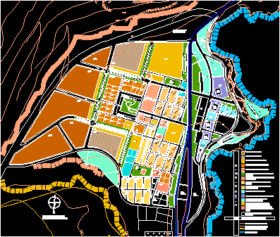
Bajo Molle Plane DWG Block for AutoCAD
Bajo Molle Plane
Drawing labels, details, and other text information extracted from the CAD file (Translated from Spanish):
no no, love, the., axis between l. or., the., the., axis between l. or., the., axis between l. or., residential use, nf., limit, dragon edge border, border edge hill tarapaca, nodes social headquarters community park., mini market, grocery store, private area projection, educational existing student housing., heritage protection archaeological monuments, for the sports use sports areas that are given in cerro dragon., communal level private service, sub service zone entertainment., residential use, buildable urban area, commercial market, buildable urban area, active industrial, community center, residential use condominiums buildings in height, public spaces not constructible, urban constructible, industrial passive, administrative industrial, hotel building threshold, beach recovery of the maritorium, hotel building threshold, central square urban park, beach recovery of the maritorium, hotel building threshold, community neighborhood square, land intended for the demand, threshold building museum, scale, sideline, via tertiary, of the neighborhood …., trade need, special trade, Cafeteria., residential., Supermarket, offices adm., kindergarten, Kinder garden, library, training center, pharmacy, corporate headquarters, mother center, college, academy, education, commercial, medical Center, Nursing, Health, market, chapels, civic Center, Social, multi-tanks, childish games, entertainment, outdoor sport, indoor sport
Raw text data extracted from CAD file:
| Language | Spanish |
| Drawing Type | Block |
| Category | City Plans |
| Additional Screenshots |
 |
| File Type | dwg |
| Materials | Other |
| Measurement Units | |
| Footprint Area | |
| Building Features | Garden / Park |
| Tags | autocad, beabsicht, block, borough level, DWG, plane, political map, politische landkarte, proposed urban, road design, stadtplanung, straßenplanung, urban design, urban plan, zoning |
