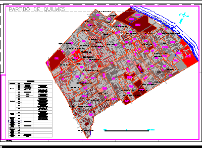
Plane Quilmes District – Bs As – Argentine DWG Block for AutoCAD
Distrct Quilmes plane –
Drawing labels, details, and other text information extracted from the CAD file (Translated from Spanish):
north, Zrv, Zeu, Zrc, Zcc, Zeu, Zeu, Zri, Zeu, Zeu, Rre, Zrr, Zrce, Zrc, Zcc, Party of quilmes, Rio de la plata, industrial, Expropriated by, Recreation, Recovery, Industrial, belt, Zrce, Road, ecological, reservation, expansion, urban, Zrv, Zeu, industrial, Excluded, Exclusive, second, Zri, residential, Recovery, residential, Excluded, Exclusive, Ree, Type of zone, commercial, Ident., Access s.e. capital, In Don Bosco for the, federal, Complementary area, Complete infrastructure, Urbanized area, Semi-urbanized area, Low population density, Semiurbanized subarea, Incomplete infrastructure, Low population density, Incomplete infrastructure, Low population density, Urbanized area, Average population density, Incomplete infrastructure, Semi-urbanized area, Low population density, Complete infrastructure, Incomplete infrastructure, Low population density, Semi-urbanized area, commercial, Bernal, Quilmes, Quilmes center, Gift ezpeleta, Commercial, San francisco solano, observations, Bernal center, Semi-urbanized area, Complete infrastructure, Urban subarea, Average population density, Incomplete infrastructure, Urbanized area, High population density, Low population density, Complete infrastructure, Urbanized area, High population density, Incomplete infrastructure, references
Raw text data extracted from CAD file:
| Language | Spanish |
| Drawing Type | Block |
| Category | City Plans |
| Additional Screenshots |
 |
| File Type | dwg |
| Materials | |
| Measurement Units | |
| Footprint Area | |
| Building Features | |
| Tags | argentine, autocad, beabsicht, block, borough level, district, DWG, plane, political map, politische landkarte, proposed urban, road design, stadtplanung, straßenplanung, urban design, urban plan, zoning |
