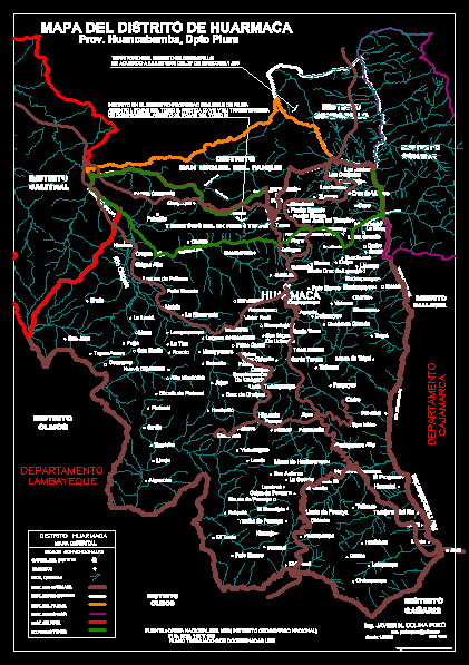
District Map Huarmaca DWG Block for AutoCAD
It has been drawn and scanned part of the national charter, the Huarmaca sector; Sondorillo, with their basins and several houses and annexes – The district represants 44% of provincial territory, this work dedicated to the memory of Carlos Neptalí to help us start this digitalizati on in 1992 in the district of Huarmaca – Peru maps
Drawing labels, details, and other text information extracted from the CAD file (Translated from Spanish):
rio huancabamba, large lath handle, hill paraton, hill picacho, hill collona, big ridge, rio huancabamba, district olmos, salitral district, district of sondorillo, district sondor, interest rio pata, hill paraton, hill picacho, hill collona, territory of the former fund, c., broken chonta, broken chajirca, Santa Ana ravine, broken chonta, interest rio chalpa, cajarana ravine, big ridge, tuluse ravine, uchupata ravine, map of huarmaca district, conventional signs, district map, district huarmaca, farmhouses, capital of the district, dist. from huarmaca, dist. from sondorillo, dist. of the faique, dist. from sondor, dist. salitral, ex background tunas, inscribed in the register real estate property of piura seat fojas tomo departure cxviii his transfer of dominion in the seat fojas tomo, source national letter of ign instituto geografico plano worked with coordinates utm., breaks, territory of the district of sondorillo in accordance with the law of March, district sallique, suck, mandorcillo, shut up, motorcycle cross, cuse, the joints, banana plantation, jajan, chalpon’s cross, little cross, coipa, burnt pampa, lipanga, wheat mines, chonta, knife, hualangayuc, White stick, white hair, palomatáz, hualapampa mines, the neck, yumbe de porcuya, porcuya lemon, union tunaspampa, from uchupite, San Miguel, pampas, fig tree, of congoña, succhapampa, hinton, pashul, White land, high miraflores, platan chonta, lemon, trapiche, waistcoat, big rock, San Martin, succhirca lagoon, victor raul, sumuche, chigna low, lanquepampa, San Juan, tupac amaru, carob tree, lambayeque, Department, lanchales, Cajarana, succha, wheat, yacht, santa cruz de lipanga, shaman, rodeopampa, san juan del temple, big broken, hualapampa high, sherbet, new hualapampa, Guayaquil, the corner place, maraypampa, false corral, suck, succharana, faiques, hualquiro, new Hope, mace, pirga, banana plantation, savila, casaguay, sahuate, congoña, rocoto, White stick, the toct, the knoll, lagoon of paltama, high chigna, molulo, shain, Chalk, Saint Rose, tall, animas, porcuya sauce, Landirca, the succha, branches, Santa Teresa, agupite, callancas, san antonio, Orange tree, yahuangate, landa, the overal, zuro, cedar, collonayuc, parguyuc, San Isidro, bug, cocule of porcuya, km., chocho, the beach, rumichaca, large stone, m., White stone, fender, avocado, tolingas, sahuatirca, spinning wheel, silahuin, the sheep farms, roses, rio huancabamba, zapotal, lemon, Progress, lalopampa, chilcapampa, huaichao, powdery, the Cider, willow, cedar, big ridge, huarmaca, rio chignia, rio chalpa, tunas, humane, river tasajeras, pasailapampa, the eucalyptus, Department, cajamarca, district olmos, district cañaris, hualcas, faicalito, district san miguel del faique, jaén, ing. javier n. hill well, dib., scale:, set, personal work with the collaboration of my friend carlos neptalí rivera, prov. Piura apartment
Raw text data extracted from CAD file:
| Language | Spanish |
| Drawing Type | Block |
| Category | City Plans |
| Additional Screenshots |
 |
| File Type | dwg |
| Materials | |
| Measurement Units | |
| Footprint Area | |
| Building Features | Car Parking Lot |
| Tags | autocad, basins, beabsicht, block, borough level, charter, district, drawn, DWG, map, national, part, political map, politische landkarte, proposed urban, road design, sector, stadtplanung, straßenplanung, urban design, urban plan, zoning |
