Plane Canton Progreso – Guayas DWG Detail for AutoCAD
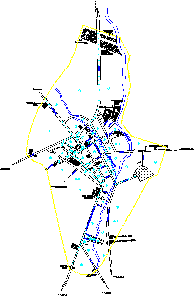
Map Canton Progreso , Guayas with details of streets
Drawing labels, details, and other text information extracted from the CAD file (Translated from Spanish):
Central Park, municipal, ss hh, mesh, scrub, structure, steps, roundabout, its T, tank, scrub, scrub, ditch, its T, tank, its T, its T, arb, strong stick, its T, structure, scrub, court, monkey, estero, estero la mona, strong stick, quarry collision, its T, Water, antenna, tank, high, sand, from palo prieto, scrub, sand, from palo prieto, scrub, from palo prieto, scrub, crops, scrub, high, scrub, structure, its T, arb, scrub, arb, arb, arb, scrub, arb, arb, arb, scrub, scrub, high, santiago luna, San Lorenzo, moises villon, marco tumbaco, San Juan, Beaches, esc. Alberto, protibulo, angel tumbaco, properties, zapotal, victor anastacio, cabbage., fernando, stand, col.san jose, garden of inf., Guayaquil, moreira, commission, traffic, pablo weber, Laura, loor, Pedro, almagro, martinez, caimito, Street, Nicolas Anastacio, Street, av.padre pedro vicente sanchez, Street, av. caimito, Street, Nicolas Anastacio, Street, cjon, Street, estero la mona, caimito river
Raw text data extracted from CAD file:
| Language | Spanish |
| Drawing Type | Detail |
| Category | City Plans |
| Additional Screenshots |
 |
| File Type | dwg |
| Materials | |
| Measurement Units | |
| Footprint Area | |
| Building Features | Garden / Park |
| Tags | autocad, beabsicht, borough level, canton, DETAIL, details, DWG, guayas, map, plane, political map, politische landkarte, proposed urban, road design, stadtplanung, straßenplanung, streets, urban design, urban plan, zoning |
