Play Defense and shore protection for the Municipality of Cobaria.
Drawing labels, details, and other text information extracted from the CAD file (Translated from Spanish):
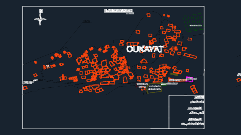
name, xfg, xeg, xfgt, xegt, xgrid, xgridt, pbase, pggrid, pegct, pfgct, pegc, pegl, pegr, pfgc, pgrid, pgridt, right, peglt, pegrt, pdgl, pdgr, graphic scale, notes, date , concept, designed and calculated :, observations, projected:, carlos humberto melo, plotter scale :, contract no., date:, contains:, scale:, file :, cedula :, mayor :, legal representative:, auditing, reference, design plan protection works, municipality of cubara, ministry of, republic of colombia, interior and of, direction of prevention, national system for prevention, and disaster relief, mp no., secretary of planning:, received :, justice, river magdalena – station the bank, percentage of time exceeded, the level of design is referred to the arbitrary system, free edge., namax., current dike cota, antioquia, Bogota, Pacific Ocean, Brazil, Peru, Ecuador, Panama, Caribbean Sea, Bolivar, Magdalena, Santander, Guajira, Sucre, Cordoba, North of, Boyacá, Cundinamarca, Choco, Narino, Amazonas, Meta, Caldas, Laughter, Quindio, Valle Cauca, Tolima, Cauca, Huila, Caqueta, Putumayo, Arauca, Casanare, Vichada, Guainia, Guaviare, Vaupes, Atlantic, Cesar, Department of Boyacá, Tunja, Cubara, location: prevention and attention, national system for the plane no .:: flat code:, marine light jury angarita, main axis, chm axis, left, coordinates spurs, spur, north, east, level, urban area municipality of cubara, a cubara, a pamplona, rio cobaria, channel to build , dike perimeter, channel slope, bridge river cobaria, aa-lot, sate sp, mountains, roads, name, line, points, pipes, boundary, fence, l. imaginary, sate, project under construction, vulomenes spurs, abscissa, volume, total volume, coordinate table, conventions, axis perimeter dike, gavion, reference spurs, river, axis spurs, via, existing gavion, volumes spurs, total volume, mats of closure, it is recommended that this battery of spurs be built in the future to avoid bridge undercutting, perimeter dam on Clarita creek, perimeter dam on Cobaria river, Clarita creek, channel to be built, plant, front view, longitudinal view , foundation level, foundation level, natural terrain, existing mattress on the river, perimeter dam, crown spur, first level, second level, third level, fourth level, fourth level, existing gavion on the river, fourth level level, fifth level, third level, fifth level, convention block, buried gabion, gavion filling, variable, channel bottom, ground slope, plan view, concrete cover, exc avacion canal, area, v.total, directional spur, channel, mat on rivera, gavion on rivera, covered with gabions and mats on rivera river broken the clarita and river cobaria, mattresses ce close, vol. accumulated, volumes mattresses talud, cant., average, t. stretch, total mats, total volume, volumes gabions talud, total, gabions, code, river cabaria, island, reference deltas, qubrada la clarita