Map symbols – File with symbols
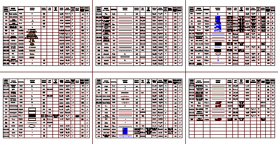
Drawing labels, details, and other text information extracted from the CAD file (Translated from Spanish):
code, object, name, object, geometry, sample, graph, geodesic point, point, leveling point, building, schools, hospitals, church, stations, cemeteries, facilities, refinery, power plant, polygon, waste area, capital , sports area, built area, line, wall, quarry, silos, swimming pool, via paved,, continuous, unpaved road, narrow, airport, airstrip, port, tunnel, pedestrian bridge, lighthouse, cable, tower, double drain , simple drainage, intermittent, coastal line, sandbar, rock bank, island, path, path, via ferrea, park, tank, well, spring, lagoon, reservoir, swamp, swamp, curve, level curve, index approximate, intermediate, intermediate, limit of nation, limit of municipality, limit of, department, moraine, permanent, point of elevation, photogrammetric, unpaved road, passable road, in dry time, via, road with, coating, funicular, heliport, cable car, toll, can nte ferreo, vehicular bridge, pipe, band, conveyor, antenna, bush, double channel, cataract, gate, lock, supplementary, glacier, dune, area, sector, path, capital of, municipality, peace, township, pelaya , inspection, diamond, hamlet, santa ines, site, fortune, neighborhood, valencia, bucaramanga, pumping, stereoscopic, aerotriangulation, clinics, for mining, police, miraflores, the corner, score, graphic, thickness, line, type , hatch, text, style, writing, shape, color, color, graphic output, construction, horseshoe, single channel, ditch, jaguey, grass pattern, ptn. ar_sand, p dots, p cross, index level, floods, p. ar_sand, patron dash, patron dots