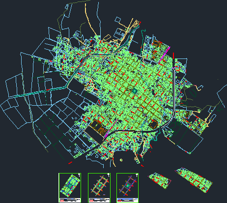
Map Tula, Mexico DWG Block for AutoCAD

All blocks and streets with ariel view of building improvements.
Drawing labels, details, and other text information extracted from the CAD file (Translated from Spanish):
project:, municipality, union of tula, ing. eduardo r. Perez Chagollan, l.e. jaime ismael diaz brambila, extension of main garden in san cayetano, municipal president, current state plan, content: public works director, scale: chiapas, tabasco, monterrey, chamizal, tlaxcala, southern cuernavaca, baja california sur, chihuahua south, south michoacan, north chihuahua, south warrior, south mexicali, south morelia, south aguascalientes, west guadalajara, north coahuila, new west leon, south peace, west america, yucatan west, north mexicali, west veracruz, south saltillo, puebla south, durango west, west monterrey, nayarit west, cd. victoria, tamaulipas south, west tepic, sinaloa west, av. south mexico, south queretaro, west oaxaca, juarez west, jalapa, west jalisco, south toluca, san luis potosi, zacatecas, east guadalajara, oaxaca, south colima, south guanajuato, hermosillo east, east sinaloa, nayarit east, jalisco, east tepic , east monterrey, veracruz, east sound, south zacatecas, west merida, east durango, pachuca, east roo quintana, east yucatan, east veracruz, merida east, north zacatecas, juarez, east queretaro, water, brazil, rain, fog, argentina , dew, crater, volcano, peru, fire, bolivia, venezuela, colombia, spain, france, germany, av. Martinique, priv. baja california, priv. oaxaca, av. mexico, canal fenced, bonnet, christmas bar, construction limit, wire canvas, visual limit, stone fence, property boundary, chapel, hill, quintana roo poniente, arroyo el castillo, arroyo the gavilan, to ejutla, north saltillo, north tamaulipas, north michoacan, north warrior, north morelia, north peace, north puebla, av. mexico norte, toluca norte, queretaro norte, guanajuato norte, colima norte, sonora poniente, villa hermosa, san rodrigo, hidalgo, prol. veracruz, culiacan poniente, morelos poniente, ciudad obregon west, zapopan poniente, road to bar de navidad, puerto manzanillo, priv. the north peace, tinaja stream, manzanero plane downtown area, underground conversion of the center of the municipal head, municipal head, path of hydraulic installations and drainage, line of hydraulic installation, drainage line
Raw text data extracted from CAD file:
| Language | Spanish |
| Drawing Type | Block |
| Category | City Plans |
| Additional Screenshots |
 |
| File Type | dwg |
| Materials | Other |
| Measurement Units | Metric |
| Footprint Area | |
| Building Features | Garden / Park |
| Tags | autocad, beabsicht, block, blocks, borough level, building, DWG, map, mexico, political map, politische landkarte, proposed urban, road design, stadtplanung, straßenplanung, streets, urban design, urban plan, View, zoning |


