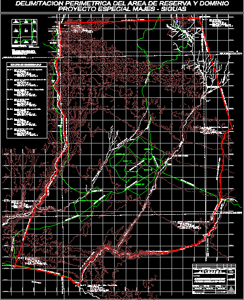
Domain Area Reserve And Special Project Majes Siguas Arequipa DWG Full Project for AutoCAD

Area Reserve and Special Project Majes Domain Siguas Arequipa in UTM and general register Arequipa Peru.
Drawing labels, details, and other text information extracted from the CAD file (Translated from Spanish):
dib., Executive Director, revised:, assistant manager, digitization:, archive:, design:, date:, approved, flat:, description, direction of territorial conditioning, autonomous authority of majors, special project majes, rev. do not., rev., scale:, code:, date, apr., km. km., meeting of the river vitor quilca pacific ocean, meeting of the naughty ravine with the river vitor, km. km., rising hill of qda. impertinent, km. km., canama area, u.t.m coordinates, location:, u.t.m coordinates, location:, u.t.m coordinates, location:, u.t.m coordinates, pto., south lat, long West, south lat, long West, south lat, long West, km. km., cerro chaupihuasi m.s.n.m., u.t.m coordinates, km. km., u.t.m coordinates, km. km., u.t.m coordinates, meeting of the qda. molles with the river majes, pto., long West, south lat, location:, long West, south lat, zone of ongoro, location:, south lat, location:, long West, section, urban reserve area, limit of national charter sheet, rio camana, south lat, long West, km. km., u.t.m coordinates, meeting of the qda. molles with the river majes, Pacific Ocean, Panamerican’s highway, pto., canama area, south lat, long West, km. km., u.t.m coordinates, location:, pto., location:, rio camana, rio majes, molle ravine, section, road majes, Panamerican’s highway, rio majes, orcopampa, ongoro, limit of national charter sheet, applause, hda. Peru, Buenos Aires, rio majes, hda. ongoro, hda. huatiapa, corire, pto., national bound sheet limit, Panamerican’s highway, km. km., long West, south lat, u.t.m coordinates, rio majes, zone of ongoro, location:, km. km., long West, south lat, u.t.m coordinates, location:, meeting of the river vitor quilca pacific ocean, pto., kilogram, rio quilca, section, molle ravine, rio quilca, section, rio vitor, Panamerican’s highway, molle ravine, follow me, broken of the holy spirit, km. km., u.t.m coordinates, meeting of the naughty ravine with the river vitor, limit of national charter sheet, want what, section, huambo road, city majes, follow me, huambo road, follow me, from tarucani, follow me, tambillo, Panamerican’s highway, Santa Isabel de Seguas, tarucani, follow me, Cerro Chaupihuasi, hill orccos, broken hausamayo, rio vitor, follow me, tarucani river, hill serai, mat, huambo, applause, mollifying, chuquibamba, the yasera, walk, rain, rio lluta, pto., chivay, arequipa, the jewel, national bound sheet limit, cracked naughty, u.t.m coordinates, location:, pto., rising hill of qda. impertinent, national bound sheet limit, hill chucchurume, km. km., long West, south lat, cerro chaupihuasi m.s.n.m., u.t.m coordinates, rio vitor, follow me, geographic location:, pto., long West, south lat, location:, long West, km. km., south lat, rio vitor, rio pichiryma, sotillo, the area of the present mosaic of plans does not include, overlapping of private properties registered with, mastery of the majes project. which are in, previous crossing of the pett to the reserve area, identification process
Raw text data extracted from CAD file:
| Language | Spanish |
| Drawing Type | Full Project |
| Category | City Plans |
| Additional Screenshots | Missing Attachment |
| File Type | dwg |
| Materials | |
| Measurement Units | |
| Footprint Area | |
| Building Features | Car Parking Lot |
| Tags | area, arequipa, autocad, beabsicht, borough level, DWG, full, general, political map, politische landkarte, Project, proposed urban, reserve, road design, special, stadtplanung, straßenplanung, urban design, urban plan, utm, zoning |


