Aerial Survey An Urban Property DWG Block for AutoCAD
ADVERTISEMENT
ADVERTISEMENT
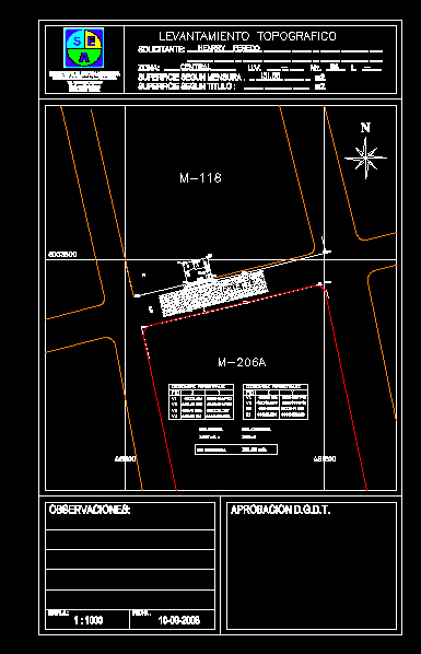
Aerial survey an urban property according guidelines urban area of the city
Drawing labels, details, and other text information extracted from the CAD file (Translated from Spanish):
topographic survey, observations:, approval d.g., specialized service in surveying, address: calle governador jose videla, specialized service in surveying, tel .:, e-mail:, santa cruz bolivia, applicant:, zone:, surface according to measurement, surface according to title, ………………………………………….. ………………………………………….. …, ……………………………….., ………………………….., …………………………….., u.v., ……………….., mz., ……….., (I.e., henry peredo, central, scale, date, street molds, affected area, coodenadas perimetrales pto., co-ordinated perimeter pto, bath, sup measure, sup affected, sup
Raw text data extracted from CAD file:
| Language | Spanish |
| Drawing Type | Block |
| Category | City Plans |
| Additional Screenshots |
 |
| File Type | dwg |
| Materials | |
| Measurement Units | |
| Footprint Area | |
| Building Features | |
| Tags | aerial, area, autocad, beabsicht, block, borough level, city, DWG, political map, politische landkarte, property, proposed urban, road design, stadtplanung, straßenplanung, survey, urban, urban design, urban plan, zoning |
Related Products

Same Contributor

Featured Products