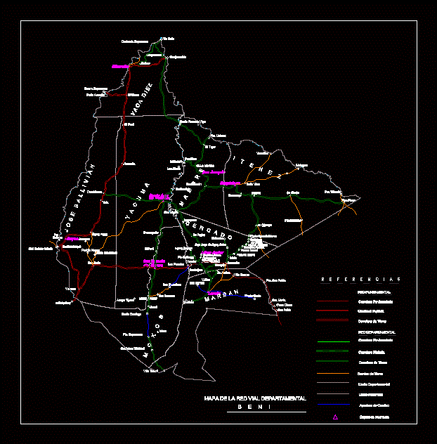
Map Of Beni DWG Block for AutoCAD

Map of Beni; provinces; critical network; departmental road network; asatadas roads; roads mugged; dirt roads.
Drawing labels, details, and other text information extracted from the CAD file (Translated from Spanish):
stadium, growth area, olimpica villa, closed coliseum, av. Pedro Blanco, Calle Bolivar, Calle Mamoré, Calle Beni, Calle Ballivián, Av. rev.alfonso elorriaga, av.federico román, av. ring road, road to puerto siles, road to san ramón, curichi, av. federico román, av. alfonso elorriaga, exit to the river machupo, road to san ramón, road to pto. siles, departure to the airport, municipal slaughterhouse, to v. c i r c u n a l a l i n, area of growth, rural area, Olympic village, municipal stadium, military barracks, military housing, military housing, hospital, coliseum, u.e. Jorge Ramallo Quiroga, u.e. chap. horacio vásquez, cemetery, park, u.e. arturo cuéllar, av. corina ojopi, san javier, loreto, trinidad, san buenaventura, a quiquibey, yucumo, san borja, pt. hope, ichoa, tiyere stream, bridges, casarabe, villa banzer, pte. san pablo, hill boy, san pablo, sta. maría, pt., salinas, santa rosa, kings, peru, australia, new hope, yellow rock, riberalta, guayaramerín, el choro, guajaramirin, pto. ustarez, versailles, firm floor, pto. villazón, of moxos, yata, cr.la moroña, san joaquin, san ramón, pto.siles, matucare, las abras, vacadiez, joseballivian, yacuma, mamore, moxos, fenced, marban, itenez, san ignacio, desengaño, santa ana , exaltation, big mount, mategua, magdalena, huacaraje, baures, sn.simón, the cármen, casablanca, sachojere, sn.andres, v.alva, camiaco, loma suarez, pto.ballivian, sn.pedro, map of the network departmental road, beni, references, fundamental network, paved road, gravel road, dirt road, departmental network, departmental limit, provincial limit, rurrenabaque, san.miguel, yacuma, beautiful view, cachuela hope, villa bella, good hope, dirt road, pto.saucedo, mituquije, santa rosa de vigo, bolivar, san lorenzo, san francisco, junrreno, new town, san bartolo, monte cris to, varador, ipurupuru, the tiger, road opening, provincial capital, jorori, santo domingo, santisima trinidad, villa tunari, ibiato, new isrrael, pata de aguila, pedro ignacio muiva, eduardo avaroa, the hill, the curve, sacrifice, san juan de agua dulce, new america, espiritu santo, cernandez, transfer report :, drawing :, this transfer is based on planes beni.dwg., archives :, original drawing :, planes beni.dwg, image jpeg references :, the following files have been excluded from the transfer :, acad.fmp, the following files were not found :, notes for distribution :, raster image files :, routes may be present in references to raster images. Make sure that these routes are correct or that the original drawing uses the correct references., the fontalt variable of autocad is defined as :, make sure that the fontalt variable has been defined in this file or another equivalent before opening any drawing. all text styles in which missing fonts are automatically defined in this typeface.
Raw text data extracted from CAD file:
| Language | Spanish |
| Drawing Type | Block |
| Category | Handbooks & Manuals |
| Additional Screenshots |
 |
| File Type | dwg |
| Materials | Other |
| Measurement Units | Metric |
| Footprint Area | |
| Building Features | Garden / Park |
| Tags | autocad, block, critical, departmental, DWG, map, network, provinces, Road, roads |


