Map Location Of The Department Of Amazonas DWG Block for AutoCAD
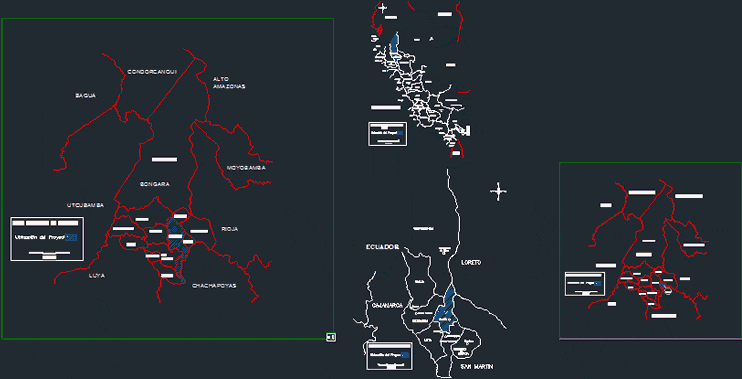
Department Location Map of Chachapoyas – Amazonas – Peru.
Drawing labels, details, and other text information extracted from the CAD file (Translated from Spanish):
nm, fl, plataf, barraj, rio, road, reser-c, baden, pst, camera, forest, qda, possible-r, catchment, house, pasa-tuber, pole, loreto, amazonas, tumbes, piura, lambayeque, cajamarca, san martin, freedom, ancash, huanuco, ucayali, pasco, lima, junin, cuzco, mother of god, huancavelica, ica, ayacucho, apurimac, arequipa, puno, moquegua, tacna, chachapoyas, tarapoto, iquitos, piura, Tumbes, Chiclayo, Cajamarca, Trujillo, Huaraz, Huanuco, Pucallpa, Cerro de Pasco, Lima, Huancayo, Huancavelica, Ayacucho, Ica, Abancay, Cuzco, Arequipa, Moquegua, Tacna, Puno, Puerto Maldonado, Ecuador, Colombia, Brazil, Bolivia , chile, pacific ocean, lake, titicaca, location of the project, political map of peru, kilometers, bagua, utcubamba, bongara, luya, chachapoyas, rodriguez, condorcanqui, mendoza, santa maria, de nieva, bagua, bagua grande, jumbilla, lamud, mendoza, political map of amazonas, high amazonas, yambrasbamba, moyobamba, rioja, florida, shipasbamba, cuispes, jazan, jumbilla, rec ta, corosh, chisquilla, churuja, san carlos, calera, legend, international limit :, national limit :, departmental limit :, provincial limit :, district boundary: rivers and streams :, project location :, district capital :, populated center: bongaea political map, bongara political map, road
Raw text data extracted from CAD file:
| Language | Spanish |
| Drawing Type | Block |
| Category | Handbooks & Manuals |
| Additional Screenshots |
 |
| File Type | dwg |
| Materials | Other |
| Measurement Units | Metric |
| Footprint Area | |
| Building Features | |
| Tags | autocad, block, department, DWG, location, map, PERU |
Related Products


Same Contributor

Featured Products


