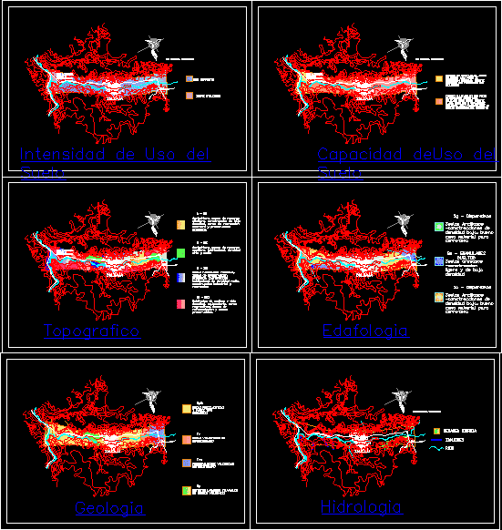
Map Salcajá, Quetzaltenango, Guatemala DWG Block for AutoCAD

Territorial Analysis near the town of Salcajá with topographic maps, land use, land use capacity, soil science, geology, and hydrology; useful as a guide to working with territorial analysis
Drawing labels, details, and other text information extracted from the CAD file (Translated from Spanish):
bus station, towards quetzaltenango, towards san totonicapan, towards labor monte bello xexac, towards santa rita, towards curruchique, towards san andres xecul, cemetery, municipality, zone, towards marroquin, step difference income quetzaltenango, of land use, get up, bus station, towards quetzaltenango, towards san totonicapan, towards labor monte bello xexac, towards santa rita, towards curruchique, towards san andres xecul, cemetery, municipality, zone, towards marroquin, step difference income quetzaltenango, soil depletion, get up, bus station, towards quetzaltenango, towards san totonicapan, towards labor monte bello xexac, towards santa rita, towards curruchique, towards san andres xecul, cemetery, municipality, zone, towards marroquin, step difference income quetzaltenango, get up, bus station, towards quetzaltenango, towards san totonicapan, towards labor monte bello xexac, towards santa rita, towards curruchique, towards san andres xecul, cemetery, municipality, zone, towards marroquin, get up, bus station, towards quetzaltenango, towards san totonicapan, towards labor monte bello xexac, towards santa rita, towards curruchique, towards san andres xecul, cemetery, municipality, zone, towards marroquin, get up, bus station, towards quetzaltenango, towards san totonicapan, towards labor monte bello xexac, towards santa rita, towards curruchique, towards san andres xecul, cemetery, municipality, zone, towards marroquin, get up, bus station, towards quetzaltenango, towards san totonicapan, towards labor monte bello xexac, towards santa rita, towards curruchique, towards san andres xecul, cemetery, municipality, zone, towards marroquin, step difference income quetzaltenango, Quetzaltenango, get up, san cristobal totonicapan, population, population, san cristobal totonicapan, correct use, over used, lands not suitable only for production purposes broken relief with steep slopes, arable land with few crops suitable for cultivation under low relief mildly high moderately intensive management productivity., water recharge, zanjones, rivers, qpit, pyroclastic rocks pumice type ignimbrita, undifferentiated volcanic rocks, tve, mainly stratified vulcanites, detritus lahárico fluvial of volcanic origin, are dispersive, qe loose granules, sg dispersive, clayey soils with good density as road material, low density light sandy soils, clayey soils with good density as road material, recharge zones construction of low recreation areas intensive ecological preservation., medium high density recharge zones., recreation areas recreation areas residential density construction industrial construction recreation, room of medium high zones zones of reforestation zones preservables.
Raw text data extracted from CAD file:
| Language | Spanish |
| Drawing Type | Block |
| Category | City Plans |
| Additional Screenshots |
 |
| File Type | dwg |
| Materials | |
| Measurement Units | |
| Footprint Area | |
| Building Features | Car Parking Lot |
| Tags | analysis, autocad, beabsicht, block, borough level, capacity, DWG, geology, guatemala, hydrology, land, map, maps, political map, politische landkarte, proposed urban, quetzaltenango, road design, soil, stadtplanung, straßenplanung, territorial, topographic, topography, town, urban design, urban plan, zoning |


