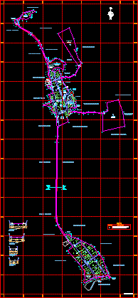
Map Tipan District, Castilla, Arequipa, Peru DWG Plan for AutoCAD

General District Comprehensive Plan Tipan in Castilla – Arequipa PERU
Drawing labels, details, and other text information extracted from the CAD file (Translated from Spanish):
bullpen, arequipa road, tipan, layout, sheet number, flat, building code, plane number, populated center, Department, arequipa, Castile, district, province, technical area, date, scale, topography:, edition:, archive, Peru Avenue, margarita street, street ramón castilla, Malecon Olaya, Peru Avenue, calle lima, torreblanca street, main square street, union passage, cemetery street, Peru Avenue, round, Street, Peru Avenue, Street, owned by third parties, river tipan, owned by third parties, state land lots, owned by third parties, sector, tipan, sector, paracolca, owned by third parties, paracolca, sector, tipan, sector, owned by third parties, other purposes, other purposes, sports area, communal services, services, communal, square, services, communal, communal, services, communal, services, communal, services, communal, services, education, sports area, communal, services, other purposes, other purposes, of health, services, services of, electrification, state land lots, ground eriazos, of the state, Malecon Olaya, third parties, river tipan, Street, lime passage, education, road yacmes, street ramón castilla, education, section, garden, sidewalk, section, sidewalk, scale:, section, sidewalk, scale:, track, sidewalk, track, garden, sidewalk, channel, sidewalk, scale:, section, track, nc grid, which will be transferred to the land registry., lots registered in the real estate register, description, symbol, legend, owned by third parties, margarita street, cemetery street, scale:, owned by third parties, property of, river tipan
Raw text data extracted from CAD file:
| Language | Spanish |
| Drawing Type | Plan |
| Category | City Plans |
| Additional Screenshots |
 |
| File Type | dwg |
| Materials | Other |
| Measurement Units | |
| Footprint Area | |
| Building Features | Car Parking Lot, Garden / Park |
| Tags | arequipa, autocad, beabsicht, borough level, castilla, comprehensive, district, DWG, general, map, PERU, plan, political map, politische landkarte, proposed urban, road design, stadtplanung, straßenplanung, urban design, urban plan, zoning |


