Maracay Venezuela DWG Block for AutoCAD

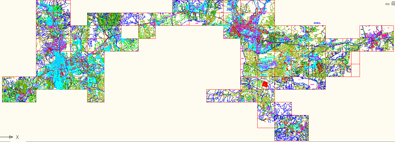
Map Maracay and par of Valencia
Drawing labels, details, and other text information extracted from the CAD file (Translated from Spanish):
coromoto, neighborhood, national road, light, barbula, rural housing, av. valmore rodriguez, av. main, the desecures, east route, cariaprima river, west route, northern route, route del cerro, route del sies, valencia highway – puerto cabello, via centro el cafe, barbula, urb. chaguaramal, barrio malagon, urb. the palm tree, hills of girardot, la sabana neighborhood, la linea neighborhood, barrio hills, urb. carialinda, urb. the entrance, the entrance, Rio retobo, qda. beautiful water, qda. girardot, hill girodot, hill retobo, via hospital carabobo, hill the dam, river cabriales, hospital carabobo, anti-tuberculosis institute, psychiatric colony, caracas-valencia highway, the guamacho, hill guamacho, c.soublete, street constitution, c. democracy, c. south carabobo, sports field, pottery, miracle farm, av. bolivar west, farm the bachacos, office of the quarry, white water, site, mariara, c. joaquin crespo, c. north carabobo, c. black first, c. cuff, c. the ruices, c. andres e. white, street diego ibarra, street fermin bull, la sabana street, c. san luis, qda. guamacho, eucalyptus street, c. diego ibarra, c.jose f.rivas, c.santander, c. future, c. urdaneta, c. andres bello, c. culture, c. Jacinto Lara, democracy neighborhood, Cerro La Virgen, Calle Marquez del Toro, Calle las Flores, Flowery Passage, Rio Guey, Agricultural Research Center, Country Club, Av. the apamates, av. the chaguaramos, av. the araguaneyes, av. the caobos, av. the cedars, av. flower of the queen, hotel, maracay, neighborhood las brisas, neighborhood san francisco, urb. rinconada, neighborhood el toro, research center, delights, horsetail line, barrio las delicias, av. the hotel, av. cantarrana, street cecilio acosta, av. bocono, liberating passage, terepaima street, c. Emerald, Calle Lara, c. santa maria, c. san cristobal, street sucre, av. araguaney, c. san antonio, street stadium, new street, street san miguel, street club, av. the delights, street sub station, av. ppal. el toro, calle el toro, passage, calle camoruco, c. the stone, c. ppal. hills of cambur, palace, episcopal, central, madeirense, democracy, guayabal, capremco, urb., main street, faculty of, main avenue, street democracy, street san rafael, street a. ravell, c. san martin, c. Lopez, c. s. Miguel, c. the florida, av. san miguel, av. the triumph, av. the orange trees, av. the citron, cjon. giraldot, new street esparta, c. falcon, c. ponderosa, av. the concord, street ruiz pineda, guzman white street, av. university, rivas davila street, calle piar, c. andrey eloy blanco, av. the samanes, street the shepherdess, av. the valley, calle los chorros, calle los mangos, av. the breezes, av. miranda, c. horizon, street traffic, aeronautical street, av. freedom, west district, neighborhood union, neighborhood la cidra, urb. el cafetal, urb. naranjal i, urb. orangery ii, urb. the pine forest, old people, asylum of, i.n.a.m., faculty of economic sciences, freeway barbula – guacara, distributor barbula, dist. naguanagua, av. the caracaros, guayabal street, av. sucre, av. bolivar, street pto. hair, street salon, calle girardot, environmental, health, medical school, faculty of education, sea breeze, urb. los caracaros, parque cabriales, urb. the guayabitos, urb. pqe. naguanagua, urb. high valley, volcano hill, montemayor hill, cupira river, hacienda cumaca, highway-barbula-guacara, san diego river, the upheaval, san diego, sabana de medio neighborhood, hacienda monteserino, c. silence, plaza, bolivar, c. the tower, calle tejeria, calle ricaurte, c. the cumaca, c. valencia, calle paez, calle junin, highway barbula- guacara, yagua, el polvero, new town, row el toco, el toco, qda. the oven, rio guacara, cerro palmarejo, row mujiquera, qda. carabalis, qda. chacao, urb. san bernardo, river ereigue, san joaquin, river areigue, b. jose tomas, gallardo, new neighborhood, caracas-valencia highway, c. coromoto, c. the indiana, c. the compadres, c. kinder, c. the little school, c. the olive tree, c. main, c. mendoza, c. santa rosa, c. merida, c. san rafael, calle trujillo, c. the cross, street the sleeve, c. Romulo Galician, c. lara, c. zulia, yaracuy street, second avenue, c. bermudez, c. piar, street andres eloy, calle joaquin crespo, c. miranda, c. anzoategui, c. yaracuy, b. black stick, b. carmen center, b. cantaclaro, street plaza, c. cedeño, c. center, national highway, of the lake, b. breezes, here ends, calle carabobo, c. sucre, c. arismendi, street miranda, calle mariño, c. Jose M. Vargas, Calle Colombia, c. santader, c. carabobo, c. aragua, c. monagas, c. santander, cura, rio cura, santa clara distributor, las vegas settlement, hacienda el amparo, finca las mercedes, turtle settlement, lake valencia, the cooperative, urb. Los Naranjos, Bellavista neighborhood, Sta neighborhood. eduvigis, sucre neighborhood, c. buccaneers, c. Bucaral, Calle El Rosal, Calle Urdaneta, Calle El Milagro, Calle Delight, Av. ppal. the cooperative, calle los jobos, calle el comando, av. ppal. santa eduvigis, street the fight, to
Raw text data extracted from CAD file:
| Language | Spanish |
| Drawing Type | Block |
| Category | Handbooks & Manuals |
| Additional Screenshots |
 |
| File Type | dwg |
| Materials | Concrete, Other |
| Measurement Units | Metric |
| Footprint Area | |
| Building Features | Garden / Park, Deck / Patio |
| Tags | autocad, block, DWG, map, maracay, topography, valencia, Venezuela |


