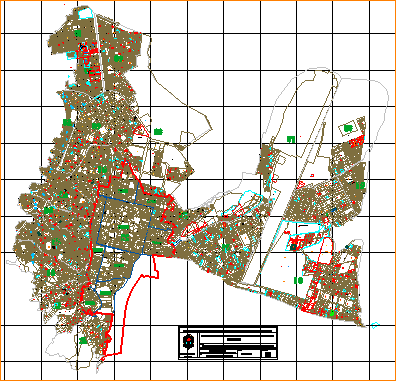
Plat Of Ayacucho DWG Block for AutoCAD

Plat of the City of Ayacucho cut apart
Drawing labels, details, and other text information extracted from the CAD file (Translated from Spanish):
vert., side, access road to the reservoir, jesus nazareno district, jr. the begonias, prop. private, broken, archaeological zone, private property, private property, zoo, risk area, intangible area, sports field, jr. los molles, pedestrian path, park, area for road, av. wonders, park, initial, education center, playground, central park and sports field, lot, river alameda, qda. tarahuayco, bridge, apurimac bridge, conchopata, parking, educational center, our lady of mercedes, pp., green area, education, sports area, basement, passage without, health, pje. common, psje. common, water channel, prlg., Quebrada Quinuapata, playground, reforestation area, property of third parties, Quebrada de Huatatas, Psje. asteroid, risk zone, channel for huayco, jr. ucayali, jr basilio auqui, sotocc chaca, jr. argentina, jr. nery g zarate, prol. san martin, jr. bolognesi, san ramon, bridge mill, ce, qda santa ana, mercury jr, jr spring, jr marte, pje madrid, temple, santa ana, qda santa cecilia, remnant lot, resulting lot, right of way, resulting, remnant, matrix , xxxxxxxxxxxx, fairground canaan low, airport, negative certificate of cadastre, taipe perez, property of inia, seridumbre of passage, sublot b, sublot a, sublot a, parent_t, matrix sublot remaining, parent plot, uca, legal servitude step, accumulation, serviente or remnant, of pongora, ccorihuillca chico, peasant community, peasant community, san cristobal de ccorihuillca, mollepata, asoc. pro housing, santisima de Trinidad, com. cam. prop. deprived of, joan mendoza quispe, remnant matrix, submanagement of, provincial municipality of huamanga, date:, plane:, technical team cadastre, dib. :, urban development plan of the city of ayacucho, location of the aa.hh., pp.jj., neighborhoods, urbanizations of the ayacucho district, planning and urban cadastre, sub lot remte., sub lot remaining, sub lot c , sub b lot, fair field canaan low, farm canaan, farm canaan ministry of agriculture, ministry of housing, construction and sanitation, agriculture ministry, tarahuayco ravine, step of servitude, cod_alterno, lot a, accumulation, matrix and step of servitude , batch matrix b, area assigned to the public road, sublot matrix, negative certificate of cadastre, matrix-mz. k, populated hauscahura, zrp, rene huaman garay, lack to determine its real location, lack, common passage, common servitude, common passage, street without name, cod-filed, missing clarify, passage, jr. the cedars, conchopata neighborhood, lack, common use, accumulated closed passage, national university san cristóbal de huamanga, national institute of culture, circus monaco de fieras, great unit mariscal cáceres, street without name, sublot c, jesus de nazareno passage, Resulting or dominant, remaining or serving, did not give, need to determine legal aspect, increase, registered remnant
Raw text data extracted from CAD file:
| Language | Spanish |
| Drawing Type | Block |
| Category | Handbooks & Manuals |
| Additional Screenshots |
 |
| File Type | dwg |
| Materials | Other |
| Measurement Units | Metric |
| Footprint Area | |
| Building Features | Garden / Park, Parking |
| Tags | autocad, ayacucho, block, city, Cut, DWG, lotizacion, plat |


