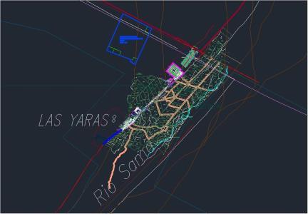
Sama The Map Yaras DWG Block for AutoCAD

MAP OF THE Yaras SAMA; URBAN AND RURAL AREA. TACNA
Drawing labels, details, and other text information extracted from the CAD file (Translated from Spanish):
plaza, yaras, rio sama, rio sama, heroes avenue of the war of the pacific, land of cultivation, area, reserved, reserved area, ends, others, communal, services, green area, passage c, sports area, property of third parties , annex miraflores, annex good view, and drain, water services, education, park, avenue andres avelino pamo, america passage, tacna street, gustavo pinto street, paula gonzales vigil street, arequipa street, moquegua street, jorge basadre street grohmann, and drainage, electricity, sub-station, street good view, other purposes, reserve area, sports, green, health, jose de san martin avenue, jiron simon bolivar, alfonso ugarte street, micaela bastidas street, jiron jose olaya, jiron francisco antonio de zela, jiron admiral miguel grau, jiron mariano melgar, avenue las palmeras, passage a, passage b, commerce, ar, property of, picardo’s sa, jiron mariano, melgar, commercial center, municipal, local communal, miraflores, good view, asoc. virgin of the snows, pet, reservoir, local, multiple, communal, av. heroes del pacifico, tap, road to the yaras, secondary roads, south pan-American, district boundary, cemetery, land eriazo state, main channel, channel, main, tambu, medium, bocatoma marango, bocatoma, the band, catambu, main channel , sama, canal de sama, canal del pino, c. p. m, annex, pampa la julia, z l, z.l., sector i, sector ii, sector iii
Raw text data extracted from CAD file:
| Language | Spanish |
| Drawing Type | Block |
| Category | Handbooks & Manuals |
| Additional Screenshots |
 |
| File Type | dwg |
| Materials | Other |
| Measurement Units | Metric |
| Footprint Area | |
| Building Features | Garden / Park |
| Tags | area, autocad, block, DWG, map, rural, Tacna, urban |


