Topographic Plane Chinchao District DWG Block for AutoCAD

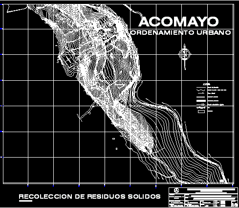
Plane with level curves of area ; Acomayo and Pachachupan – Include urban distribution Acomayo and Pachachupan populated centers
Drawing labels, details, and other text information extracted from the CAD file (Translated from Spanish):
countryside, holy, higher education, camal, fairground, collection center, rdm, zte, etr, etr, rdm, rdm, rdm, ces, zte, ces, rdm, not supported, applications, service center equipment, commercial axis, sports recreation area, recreational touristic axis, special treatment area, special uses, educational equipment, health equipment, market, residential average density, housing workshop, areas, central area, ces, etr, zte, single family dwelling, rdm, single family Home, multifamily housing, soil use compatibility, conditioned, compatible, accomodation computer plan, transport terminals, agricultural industrial trade, ind. complementary elementary, ind. light, of med., center of recreation men., neighborhood trade, wholesale trade, traditional market, institutional premises, restaurants, department store, automotive workshops, faucets, educational facilities, cultural places, sports venues, section, section, strong central section, section, section, strong, section, section, strong, section, strong pedestrian, sector, zoning, scale, top. cesar chavez cabrera, ing. F. manuel ochoa legua, location, I accomodate, scheme of urban reorganization of accommodation, zoning, victor hugo collazos linares, district municipality of, chinchao, ing. livilier ramos nolasco, approval, responsible professional, drawing autocad:, design, flat, owner, draft, district, Location, Department, province, jr. two of May nº cel. huánuco, architect, scale, date, chinchao, huánuco, huanuco, I accomodate, sheet, horseshoe path, sports field, affirmed road, sewer syphon, azalpate road, River, households, level curves every mts., irrigation canal, side take, national college of pacahachupan, river iguarizo, pachachupan stadium, broken course, Pedestrian bridge, pachachupan market, tingo maria road, carriage bridge pillao, urban planning, I accomodate, road affirmed micho, affirmed highway pillao, zoning, scale, road affirmed huachacancha, central highway huánuco tingo maria, households, River, azalpate road, sewer syphon, affirmed road, side take, irrigation canal, level curves every mts., urban planning, I accomodate, jr. chinchao, EC. no, accommodation stadium, accommodation cemetery, entrance road, January extension, sport slab, jr. of June, I accomodate, municipality, unheval, chapel, av. from January, weapons, square of, I accomodate, staircase, road tungra, water channel, unheval, jr. of July, market, catholic, church, community House, evangelical, church, clas, I accomodate, huanuco, reflection park, irrigation canal, rio iguarizo, irrigation canal, huanuco, irrigation canal, tingo maria, rio iguarizo, I accomodate, urban planning, responsible professional, ing. livilier ramos nolasco, chinchao, district municipality of, ing. F. manuel ochoa legua, road sections compatibility of use, scale, approval, owner, I accomodate, location, top. cesar chavez cabrera, sheet, victor hugo collazos linares, architect, jr. two of May nº cel. huánuco, road sections, scheme of urban reorganization of accommodation, flat, drawing autocad:, design, date, scale, draft, Department, Location, province, dis
Raw text data extracted from CAD file:
| Language | Spanish |
| Drawing Type | Block |
| Category | City Plans |
| Additional Screenshots |
 |
| File Type | dwg |
| Materials | |
| Measurement Units | |
| Footprint Area | |
| Building Features | Car Parking Lot, Garden / Park |
| Tags | area, autocad, beabsicht, block, borough level, curves, distribution, district, DWG, include, Level, plane, political map, politische landkarte, proposed urban, road design, stadtplanung, straßenplanung, topographic, urban, urban design, urban plan, zoning |


