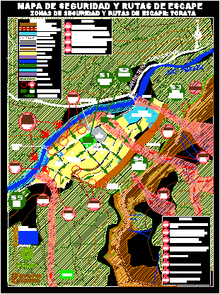
Torata Plane – Peru DWG Block for AutoCAD

Torata plane – Peru
Drawing labels, details, and other text information extracted from the CAD file (Translated from Spanish):
you predes, study center, disaster prevention, you predes, Office of, humanitarian aid, European Comission, oxfam, cheerful jungle street, passage, cheerful jungle street, binational road, cheerful jungle street, Street, cheerful jungle street, passage, cheerful jungle street, Street, cheerful jungle street, calle loreto, passage, Torata street, street level, passage, passage, chacani’s ravine, retirement ticket, loreto ticket, Salsipuedes passage, Street Bolivar, alfonso ugarte street, capitan becerra street, Torata street, los jazmines street, passage, Street Bolivar, street nicolas de pierola, street mariscal caceres, july street, passage, sergeant vilca street, omate street, alfonso ugarte street, capitan becerra street, highway, binational, legend, rio torata, stadium, school, bridge, Park, police station, square of, place of, Health, church, center, services, communal, municipality, market, housing workshop, other uses, Health, recreation, education, summit line, critical points, living place, filling areas, exposed areas, landslides, exposed areas, activation of gullies, exposed areas, floods, slope edge, broken line, calle colonel manuel de la torre, reservoir, Christ, weapons, civic, White, agricultural area, legend, Possible landslides, carcass activation, buildings at slope boundary, settlements of the road, Possible flooding huaycos, activation of the chacani gorge, rain, flood due to water accumulation, constructions on steep slopes, settlements by, by landslides of flexible floors, collapses on the binational road, filtration for irrigation in agricultural area, settlements moisture product of, without considering retaining walls, on the hill, erosion in slope boundary in, both margins of the river Torata, river taorata, apples, street entrance, m. of the tower, gauge, caribbean, chacani, Apple, street to ugarte, the century, Hill, the century, Hill, Apple, j. c. mariategui, security zones, escape routes, square of, weapons, Park, zone, agricultural, adjacent, zone, agricultural, adjacent, security zones escape routes: torata, safety map escape routes, area, free, apples, apples, legend, geographical faults, amplification of seismic waves, by cut of slope, sliding settlement, overflow irrigation canal
Raw text data extracted from CAD file:
| Language | Spanish |
| Drawing Type | Block |
| Category | City Plans |
| Additional Screenshots |
 |
| File Type | dwg |
| Materials | Other |
| Measurement Units | |
| Footprint Area | |
| Building Features | Car Parking Lot, Garden / Park |
| Tags | autocad, beabsicht, block, borough level, DWG, PERU, plane, political map, politische landkarte, proposed urban, road design, stadtplanung, straßenplanung, torata, urban design, urban plan, zoning |


