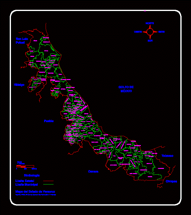
Veracruz State Map DWG Block for AutoCAD

Sketch; only with the municipality of Xalapa Veracruz map
Drawing labels, details, and other text information extracted from the CAD file (Translated from Spanish):
gulf of, mexico, puebla, hidalgo, san luis, potosi, tabasco, chiapas, oaxaca, simbology, state boundary, municipal boundary, state of veracruz map, source: inegi, xii general population and housing census, scale, north, south, west, east, panuco, old town, tampico alto, tamalin, fig, tempoal, tantoyuca, platon sanchez, chalma, chiconamel, tamiahua, chinampa de gorostiza, orange amatlan, tancoco, tantima, chontla, ixcatepec, tepetzintla, hill blue, chicontepec, temapache, tuxpam, herrera cazones, tihuatlán, castillo, de teayo, madero, ixhuatlán, benito juarez, tlachichilco, texcatepec, zacualpan, huayacocotla, zontecomatlan, ilamatlan, papantla, gutierrez zamora, tecolutla, coatzintla, coyutla, spinal, zongolica, martinez de, the tower, nautla, misantla, atzalan, tlapacoyan, vega de la torre, high star of, gutieerez neighborhoods, actopan, colipa, yecuatla, emiliano zapata, perote, juchique de ferrer, chiconquiaco, tenochtitlan, altotonga , jalacingo, my nas, villa aldama, the beams, tlacolulan, coacoatzintla, tonayán, miahuatlán, acatlán, tepetlán, naolinco, landero and coss, tatatila, jilotepec, xalapa, coatepec, acajete, tlalnelhuayocan, banderilla, rafael lucio, ramirez, ayahualulco, xico, ixhuacán de, the kings, cosautlán de, carvajal, teocelo, tlaltetela, jalcomulco, apazapan, national bridge, tlacotepec de mejia, totutla, tenampa, sochiapa, comapa, huatusco, ixhuatlan, coffee, zentla, tepatlaxco, calcahualco, alpatláhuac, coscomatepec , tomatlán, chocamán, córdoba, atoyac, amatlán de, fortín, ixtaczoquitlán, step of the male, the pearl, atzacan, mariano escobedo, ixhuatlancillo, orizaba, maltrata, walnuts, huiloapan, rio blanco, dressing room z. mendoza, acultzingo, solitude atzompa, tequila, atlahuilco, xoxocotla, tlaquilpa, astacinga, tehuipango, mixtla, texhuacán, tezonapa, omealca, cuitlahuac, yanga, cuichapa, naranjal, coetzala, carrillo port, shrimp, sheep crossing, ursulo galván, veracruz , mouth of the river, altamirano, bend welding, jamapa, medellín, cotaxtla, tlalixcoyan, white earth, alvarado, igancio de, the key, tlacotalpan, terdo de tejada, saltabarranca, angel r. cabada, acula, ixmatlahuacan, amatitlán, carlos a. carrillo, cosamaloapan, three valleys, tlacojalpan, chacaltianguis, otatitlan, jose azueta, island, santiago tuxtla, san andres tuxtla, juan rguez., clara, beach vicente, hueyapan, catemaco, mecayapan, soteapan, tatahuicapan, acayucan, san juan evangelist, sayula de alemán, texistepec, jáltipan, oluta, soconusco, pajapan, minatitlan, the choapas, coatzacoalcos, fresh water, moloacán, cosoleacaque, ixhuatlan of the southeast, uxpanapa, hidalgotitlán, jesus carranza
Raw text data extracted from CAD file:
| Language | Spanish |
| Drawing Type | Block |
| Category | Handbooks & Manuals |
| Additional Screenshots |
 |
| File Type | dwg |
| Materials | Other |
| Measurement Units | Metric |
| Footprint Area | |
| Building Features | |
| Tags | autocad, block, DWG, map, municipality, Sketch, state, veracruz |


