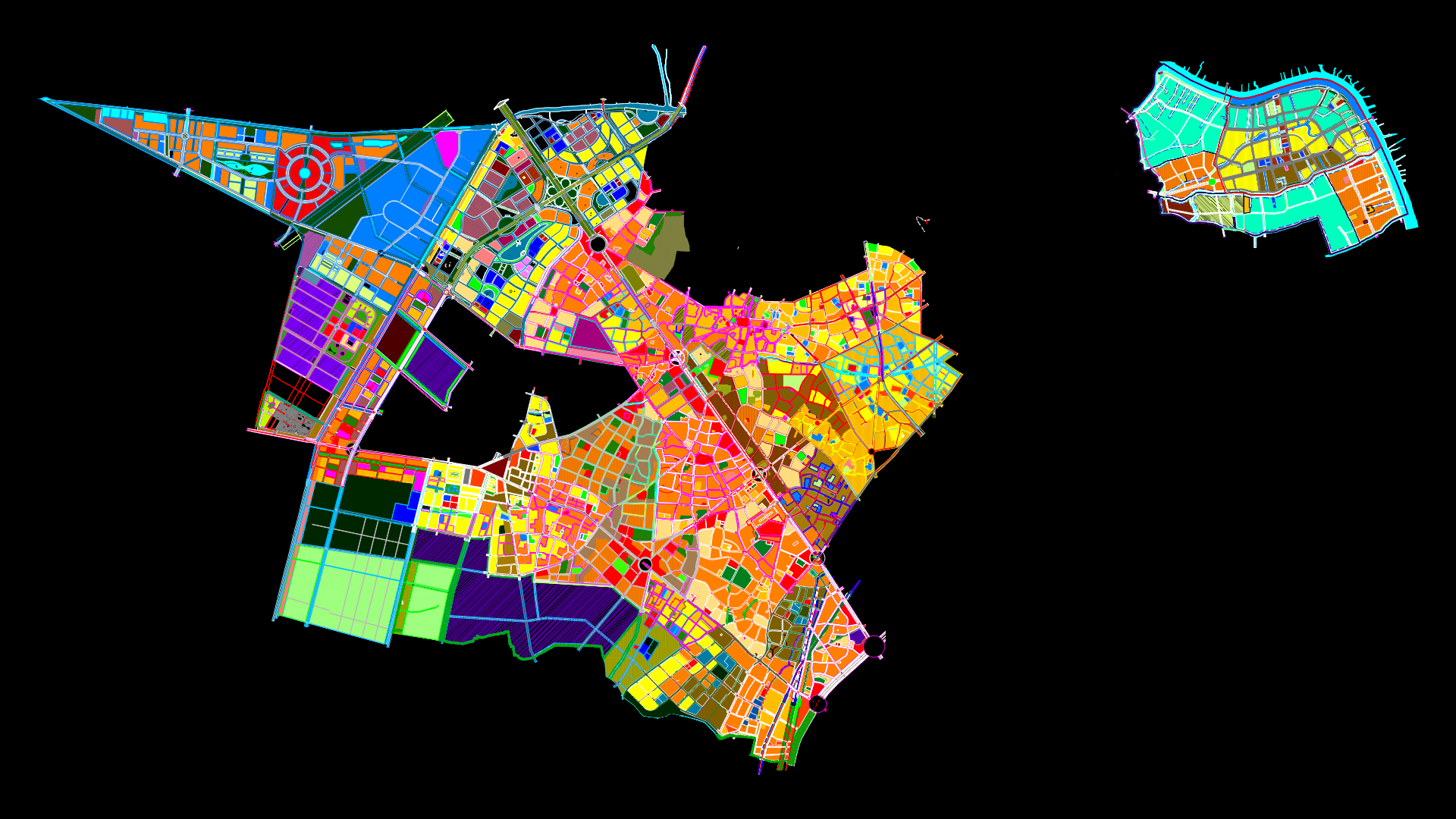
Yungay City Cadaster DWG Block for AutoCAD

Urbane cadaster of Yungay city
Drawing labels, details, and other text information extracted from the CAD file (Translated from Spanish):
flat location, use of via, street los andes ml., chavin, ancash, independence, huaraz, the looker, scale:, jr. The Andes, sheet:, Department:, region:, district:, urbanization:, province:, lot:, shred:, Apple:, owners, georeferenced, scale:, stamp signature:, owner:, date:, scale:, flat:, use of via, use of single family home, calle el mirador with ml., use of single family home, second strap with ml., second strap with ml, professional:, indicated, draft:, single family Home, georeferenced location, February, Mrs. hope josefina sandoval saenz, location, ml., floors, height, orient., partial, total, first floor, areas, draft, area chart, north, East, south, West, ml., rooftop, built area, area of land, third floor, second floor, perimeter, free area, occupied area, r.n.c., settings, net density, maximum height, free area, parking lot, frontal withdrawal, perimeter uses, coefic. of building, applications, regulatory framework, adjoining features, viv., school, water channel, viv., living place, home, rock, eriazo, ground, tap, ancash, channel, water channel, marginal strip, ground eriazo, eriazo, ground eriazo, viv., viv, santa, peasant community ancash, home, path, en, households, houses, home, households, path, households, houses, area of circulation, passage, Street, jr. of May, projected street, grandstand, z.l, qda. runtu, channel, irrigation ditch, households, eriazo, arborea, coverage, ground, viv., a, reservoir, eriazo, viv., caraz, piquip, church of, living place, viv., horseshoe, way of, households, EC, viv., living place, viv., ground eriazo, home, living place, rock, houses, shrubbery, ground eriazo, eriazo, households, home, eriazo, Street, passage, Street, viv., school, water channel, viv., living place, home, rock, eriazo, ground, ancash, channel, water channel, ground eriazo, viv., viv, home, path, en, households, home, path, households, area of circulation, passage, Street, jr. of May, projected street, grandstand, z.l, qda. runtu, channel, irrigation ditch, households, eriazo, ground, viv., a, eriazo, viv., caraz, piquip, church of, living place, viv., horseshoe, way of, lots, households, EC, viv., living place, viv., ground eriazo, home, living place, rock, houses, shrubbery, ground eriazo, eriazo, households, home, Street, Street, Street, av. freedom, street nº, Street, street nº, passage, sports area, passage, education, other purposes, education, ml., Street, Park, av. freedom, passage, street nº, Street, passage, agricultural plots, Street, Street, Street, Park, Street, pier, passage, Street, pier, Street, AC. Saint Rose, Street, Park, Street, passage, communal service, passage, passage, Street, passage, Street, service, communal, Park, passage, Street, exclusive, ml., area, highway, Street, communal service, education, ml., l.c., ml., ml., ml., ml., education, Park, health Service, Street, passage, Street, passage, Street, passage, Street, passage, Street, passage, Street, passage, Street, passage, Street, passage, Street, sporty, area, water drain, ml., passage, passage, passage, Park, communal service, santa, primary of, support, passage, free area, free area, free area, free area, green area, ml., Park, ml., passage, communal service, passage, Park, passage, green area, green area, ml., ml., passage, green area, passage, passage, ml., Street, Park, passage, passage, ml., ml., Street, passage, green area, ml., Park
Raw text data extracted from CAD file:
| Language | Spanish |
| Drawing Type | Block |
| Category | City Plans |
| Additional Screenshots |
|
| File Type | dwg |
| Materials | Other |
| Measurement Units | |
| Footprint Area | |
| Building Features | Car Parking Lot, Garden / Park |
| Tags | autocad, beabsicht, block, borough level, cadaster, city, DWG, political map, politische landkarte, proposed urban, road design, stadtplanung, straßenplanung, urban design, urban plan, urbane, yungay, zoning |
Related Products


Same Contributor

Featured Products


