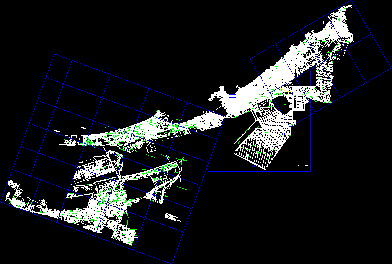
Design Otoch Paraiso Villages DWG Full Project for AutoCAD

Location Social Housing – Type of drawing – .Irregular lots – Lots to trade – Areas of donation – Project in stage design
Drawing labels, details, and other text information extracted from the CAD file (Translated from Spanish):
children’s garden, elementary school, a tulum, a cancun, caribbean sea, fiscal dock, ejido colony, center, colony luis d. colosio, zazil-ha colony, gonzalo guerrero colony, nicte-ha colony, playacar, games, children, amacas, palapa, multiple-uses, grill, toilets, solarium, with water, losmatorra le s, fracc.galaxia del carmen i and ii , area of donation, riouribe, rio ameca, flowery river, river conchos, rio lerma, rio santa maria, rio grande, rio san pedro, rio san fernando, rio panuco, av. Rio Bravo, Rio Fuerte, Rio Soto La Marina, Lagoon Nichupte, Rio Grijalva, Bojorquez Lagoon, Monte Bello Lagoon, Laguna de Terminos, Lake Chapala, Mother Lagoon, Buenos Aires Lake, San Martin Lake, Lake Bayano, Lake Ibai , avenue luis donaldo colosio, avenue paseo del mayab, avenue petempich, the glory, ranch montecarlo, rabiorcado estate, hotel, caracol village, road, connection, the corchalito, real estate el corchalito, access, owned by wilberth solis, av. in project, right of way project, francisco j. novelo cardenas, bertha r. novelo cardenas, lucia from c. novelo cardenas, urbelina of the s. sansores gabourel, miguel r. novelo cardenas, the pirate estate, the sea jungle, the bushes, the lemonade estate, rabiorcado fraction i, access, wading pool, palapa, meeting, closed hedgehog, closed sea star, closed the corals, closed the snails, playa del sol , donation, pedestrian, Paseo de la Castellana street, closed Paseo de la Castellana, Paseo de Andalucia street, Paseo de Salamanca street, closed promenade of Salamanca, Paseo de Castilla street, Paseo del Vicero street, closed walk of the Viceroy, Paseo de segovia, closed paseo de segovia, av. chemuyil, av. sian ka’an, av. without name, multiple use court, mission villamar ii, area for children’s garden, cape verde islands, society islands, carolinas islands, balearic islands, bali island, ibiza island, corcega island, bahamas islands, isla de java, azores islands, bermuda islands, victoria island, tenerife island, easter island, falkland islands, crete island, mallorca island, marshall island, elementary school area, mariana islands, georgian islands, galapagos islands, hawaii islands , islands of santa maria, feroe islands, islands of tahiti, islands of malta, island of honshu, commercial area, avenue islands antilles, telered, access road, sian kaan avenidad, private beautiful beach, private enchanted beach, private beach oasis, common use, lands of, lane, primary street, axis, sidewalk, camel, green area, stream, parking, proposed road section, lot limit, a.verde, secondary street, road section, tertiary street, trade, donation, palapa , p. cfe., booth, security, registry, a. residuals, common use lands, treatment plant, location sketch, date:, project:, owner:, location:, scale:, plane:, dimensions:, meters, polygonal, cancun q, roo. mex., topography and studies, terrestrial s.a. from c.v., cadu inmobiliaria, s.a. cv, campeche, state, belize, caribbean, sea, yucatan, white, othon p., morelos, maria, jose, port, felipe carrillo, solidarity, juarez, benito, women, island, cardenas, lazaro, cozumel, croquisdeubicacion, marcaibe, a pt. Morelos, a tulum, side, coordinates, distance, course, est, path access, technical notes: these polygonal correspond to the physical survey, being found old spins of the parcel, original., this survey was carried out in October, the coordinates were taken from the certificates, parcelarios., indicate in the parcelarios certificates., avuc b, a.v.u.c. c, common use, green area, common use, common use, common use, common use, a.v.u.c. f, a.v.u.c. g, closed street, access zone, street cda., common use, common use, common use, common use, common use, common use, common use, common use -l, common use-n, common use-o, common use-and, avuc r, a.v.u.c. s, common use-x, a.v.u.c. u, a.v.u.c. v, common use-z, municipal roads, portico, project, parking spaces, coefficient of land use, percentage max. of ocup., stamp of authorization of urban development, cus, cos, net density, maximum height in, restrictions min., total surface:, use of the land, to the boundaries, front of the lot, area of the lot, demolition, new construction , levels, background, front, standard, type of license, extension, economic permit, modification, regularization, complies, others, extension, housing, ground floor :, second level :, first level :, basement :, commercial, address, data of the author of the project, professional name, telephone, name, location sketch and north, key :, date :, project:, plan :, owner :, location :, scale :, dimension :, land use table project, plot , surface, total, road surface
Raw text data extracted from CAD file:
| Language | Spanish |
| Drawing Type | Full Project |
| Category | City Plans |
| Additional Screenshots |
 |
| File Type | dwg |
| Materials | Other |
| Measurement Units | Metric |
| Footprint Area | |
| Building Features | Garden / Park, Pool, Parking |
| Tags | areas, autocad, beabsicht, borough level, Design, drawing, DWG, full, Housing, irregular, location, lots, paraiso, political map, politische landkarte, Project, proposed urban, road design, social, stadtplanung, straßenplanung, trade, type, urban design, urban plan, zoning |


