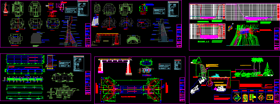
Location Plane Perimeter – Peru – Moquegua DWG Block for AutoCAD
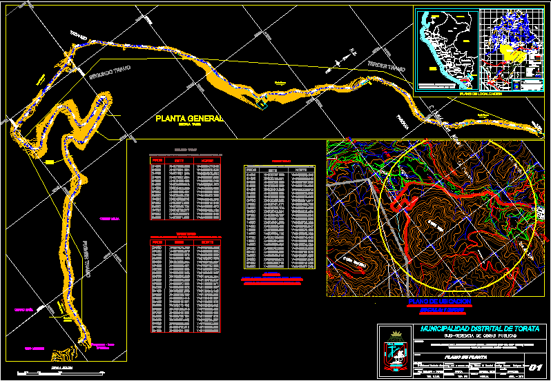
At this level we can appreciate the presentation of a key map topographic, location and location of a road work.
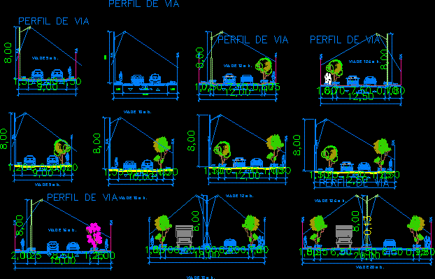
Drawing labels, details, and other text information extracted from the CAD file (Translated from Spanish):
nm, by ghost, agustin de, torata, san, heroic villa, and congo, allegory, cross of the century, the pascana, the band, road to cuajone, north, east, prog, existing channel, pine, yacango, pascana, trees , griffin mdt, road to cuajone, bull, reservoir, house, inc, slab dptva., housing, ravine, cover, underground channel, garden, alley, water crossing, access to the pascana, access to legoma, alc., sewer , output channel matrix and channel, channel matrix and channel, channel channel step yacango, landfill, side channel, mill, channel to the mill, slope, sardinel, wall, housing, fence, first section, second section, third section, mother of God , huancayo, huancavelica, ica, tacna, puerto maldonado, puno, ayacucho, apurimac, arequipa, cuzco, abancay, pasco, junin, hill of pasco, huanuco, ancash, lima, huaraz, cajamarca, liberty, trujillo, chiclayo, san martin, piura, amazonas, chachapoyas, lambayeque, moyobamba, ucayali, pucallpa, loreto, iquitos, pacific ocean, chile, bolivia , brazil, ecuador, colombia, moquegua, moquegua, torata, location of the department of moquegua on the map of peru, macro location map, scale: graphic, sub-management of public works, district municipality of torata, investment management, monore , pachas, mimilaque, mimilaque river, tambo river, mollesaja, airport, refinery, bolivia mar, coquina mine, deep gulch, huarangayo, colohuachi, pantín, cacahuara, yaribaya, santa clara, pillone, arapa, yanapuquio, antajahua, maycunaca, totorani , yanahuara, miraflores, pampa clemesi, homo, la bodeguilla, corpanto, san josé, count, santo domingo, charsagua, los angeles, alto la villa, chen chen, san francisco, san antonio, pampilla, curo, umalso, sicuani, cruiser , jesus maria, paltuture, pachamayo, tassa, querala, coalaque, animas, san cristóbal de torata, sacohaya, tonohaya, querapi, titi, escacha, huasacache, ronjadero, pond, pampa pains, sabaya, orlaque, chacahuayo, pocohuayo, lulio, the huata, hembruna, caiman , Sojamure, Seche, Talahuayo, Challahuaya, Vinomore, Moromoro, Santa Cruz, Chimpaypampa, Pallatea, Candahua, Hirhuara, Aruntaya, Titire, Yaragua, Chilligua, Huachunta, Chilota, Tala, Chujulay, Jahuay, Otaora, Quele, Ilubaya, Coplay, yacango, buenavista, the common, pocata, tumilaca the mill, estuquina, arondaya, hot, coscore, asana, the chapel, osmore, yerba buena, pocoma, the gazebo, pampa wireless, city garden, mine cuprita, copper mines de chapi , graphic scale, Pan-American Highway, to Arequipa, Chacapunco, Punta Coles, Smelting, Binational Highway, Gully Wave, icuy Point, Puite Mine, to Tacna, coastal road, to drainage, Villa Botiflaca, Dead India, White Water, Ulucan, palcamayo, calepa, sahuanay, salinas moche, a puno, anascapa, carachaje, huarina, huatagua, san miguel, lucco, yalagua, camata, exchaje, tolapalca, oyo oyo, chaje, ancopujo, pacchani, calazaya, coroise, muylaque, san cristobal , via without affirming, railway line, new town, pacific ocean, via ferrea, carrozable trail, via affirmed, via asphalted, communication roads, departmental capital provincial capital district capital district limit provincial limit departmental limit lagoons and rivers, conventional signs, source: i. g. n. – g.r.m. – m.t.c. – i. n. and. i., lag. villanerani, lag. paringota, lag. brave bull, lag. of camaña, lag. lacacota, lag. asiruni, lag. jucumarini, huamure river, uturuncane river, san antonio river, jancojahuira river, cruzane river, pacocahua river, liuchune river, janquiri river, jucmarini river, laramacota river, vilullo river, pisco ota river, parumayo river, jayumayo river, chaje river, river cruise, river anchallani, river, river, casting, river paltuture, river ichuña, river rate, river coalaque, river querala, river ancotia, river chaclaya, river huancune, river cancosane, river for, river huanacune, river pichupichu, river tocamayo, river chucullusca, river chacahuayo, river chocavique, puquina river, river seche, river chapel, river esquino, river pastillo, river chahuarani, river vagabundo, river omate, river aguada good, yellow river, river culine, river chaquimayo, river chacalaque, Curo River, Tumilla River, Yarihualla River, Torala River, Chojata River, Chupria River, Chiquirani River, Cocalí River, Coralaque River, Volcanmayo River, Ubinas River, Chinchela River, Cota River, Marcaballe River, Yolgache River, Pulojahuira River, River I fell matazo river, pachani river, titire river, queulliri jahuira river, aruntaya river, javira river, chincune river, vizcachas river, chilota river, saltiajahuira river, calasaya river, tocco river, huaytire river, mazocruz river, callaza river, river putina, river cuchumbaya, carumas river, samahuaca river, sajena river, paralaque river, chujulay river, titijones river, cuajone river, altarani river, charaque river, asana river, capillune river, otora river, torata river, tumilaca river, moquegua river, osmore river , lagoon salt, lagoon large grass, subin, amata, charicucho, tin tin, chichilin high, chichilin bajo, quinistacas, escobaya, cogri, urinay, queanto, tasata, huatalaque, the common, sotolojo, ataspaya, pacagua,
Raw text data extracted from CAD file:
| Language | Spanish |
| Drawing Type | Block |
| Category | Roads, Bridges and Dams |
| Additional Screenshots |
 |
| File Type | dwg |
| Materials | Other |
| Measurement Units | Metric |
| Footprint Area | |
| Building Features | Garden / Park |
| Tags | autocad, block, DWG, HIGHWAY, key, Level, location, map, moquegua, pavement, perimeter, PERU, plane, presentation, Road, route, topographic, work |
Related Products
Same Contributor

Featured Products


