Tepotzotlan Plane DWG Block for AutoCAD
Tepotzotlan Plane – Mexico
Drawing labels, details, and other text information extracted from the CAD file (Translated from Spanish):
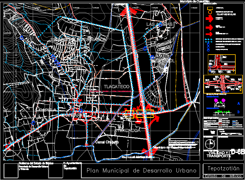
h. city council, tepotzotlán, government of the state of mexico, secretariat of urban development, and housing, simbología :, scale :, orientation :, date :, location :, key :, name of the plane :, road and transport, vehicular flow, capacity road, conflicting cruises, primary roads, road sections, regional roads, intensive, medium, low, basic symbology: electric power line, local roads, municipal boundary, tepotzotlán park limit, public property limit, historical center limit, level curve , canal, river, runoff, primary road, regional roads, urban layout, animas, trebol, texcacoa, tlacateco, ricardo magón flowers, san martin, capula, municipality of cuautitlan izcalli, municipality of cuautitlán, a queretaro, río hondo de tepotzotlán, canal chiquito, a mexico df, federal, regional urban transport routes, local urban transport routes, urban transport stops, taxi bases, pedicab bases, June
Raw text data extracted from CAD file:
| Language | Spanish |
| Drawing Type | Block |
| Category | Roads, Bridges and Dams |
| Additional Screenshots |
 |
| File Type | dwg |
| Materials | Other |
| Measurement Units | Metric |
| Footprint Area | |
| Building Features | Garden / Park |
| Tags | autocad, block, DWG, HIGHWAY, mexico, pavement, plane, Road, route |
Related Products


Same Contributor

Featured Products


