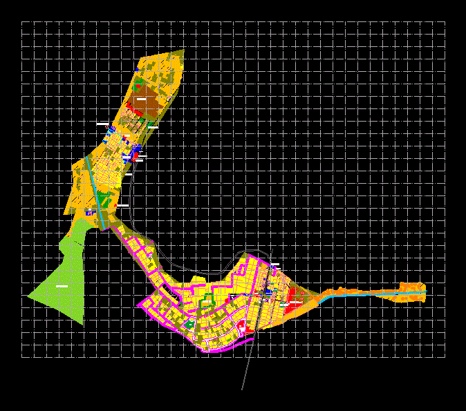
Zoning Map, Metropolitan Lima DWG Block for AutoCAD

Zoning 2010 – Quadrant 10E Ate – Vitarte; Chaclacayo; Cieneguilla; Lurigancho – Chosica IMP; Datum PSAD56 – 18S
Drawing labels, details, and other text information extracted from the CAD file (Translated from Spanish):
zoning in force, district, ate, zoning sheet, current zoning, no change, zoning in force, district, ate, zoning sheet, current zoning, no change, zoning in force, district, ate, zoning sheet, current zoning, no change, zoning in force, district, vitarte, zoning sheet, current zoning, no change, zoning in force, district, ate, zoning sheet, current zoning, no change, zoning in force, district, vitarte, zoning sheet, current zoning, no change, cerro san juan, av. daniel alcides carrion, av., av. jaime zubieta, zrp, zonal park, zrp, zrp, zhr, zrp, zrp, zrp, zhr, zrp, zhr, zrp, aspn, zonal park nº, zonal park, huaycan de pariachi, archeological site, sector, cemetery, aspn, aspn, zrp, archaeological area, little glory, central Road, av. Union, av. forest, av. broom, av. eucalyptus, av., zrp, aspn, zhr, aspn, aspn, zrp, zrp, zonal park, z.a., huascata, archit., picture, urb., alfonso cobian, zrp, rio rimac, zrp, irrigation ditch, aspn, aspn, av. of the pantheon, av. bernardo morales, av. the sunflowers, av. parachutists, sun field, av., av. September, av. from, September, av. the, willows, av. Guadalupe’s Virgin, av. new Horizon, av. Virgin, from Carmen, av. caper, palm road projection, reservoir, EC. faith joy, council of lurigancho, agency nina, monastery of the, visitation, antonio background, picture, Bottom the legs, great huaca, deep the ravine, paltas farm, the foal, poultry farm, San Miguel, carapongo background, college, station, tahuacucho, reservoir, caraponguillo background, postulate, La Salle, brick wall, the Macarena, background, villaeste, saracancha, allpacancha, ruins, caper, archaeological area, capapongo, archaeological area, the age, archaeological area, huaca choruro, rimac, River, rio rimac, zrp, zhr, av. parachutists, archaeological area, the age, Inca union, sismologica nena, the foal, zhr, zrp, zrp, archaeological area, big glory, archaeological area, zrp, zrp, rio rimac, zrp, zrp, aspn, ruins, archaeological area, huaycán de pariachi, zhr, zrp, area, park nº, av. the brooms, AC. the oaks, AC. the ficus, HE., AC. rainbow, AC. Sun, AC. the Palm trees, communal, local, church, psj. the plums, psj. buts, psj. the cherry trees, street apple trees, union avenue, calle los naranjos, street peaches, sports, countryside, the pacaes, street the orchids, street thoughts, street roses, street tulips, street the violets, corrals, street the petunias, reserved area, area, reserved area, risk area, reserved area, Park, reserved area, Park, reserved area, risk area, communal service, public, Park, communal service, play area, sporty, area, communal, service, Service, Park, reservation, area of, Park, education, communal, service, Health, services, communal, communal, services, sports area, Park, Park, Park, Park, Park, Park, Park, reserved area, reserved area, reserved area, reserved area, area, reserved, communal service, communal service, area, reserved, Park, Park, Park, communal service, sports area, serv. communal, reforestation area, serv. communal, Park, Park, risk area, Park, reforestation area
Raw text data extracted from CAD file:
| Language | Spanish |
| Drawing Type | Block |
| Category | City Plans |
| Additional Screenshots |
 |
| File Type | dwg |
| Materials | |
| Measurement Units | |
| Footprint Area | |
| Building Features | Car Parking Lot, Garden / Park |
| Tags | ate, autocad, beabsicht, block, borough level, chaclacayo, DWG, lima, lurigancho, map, metropolitan, political map, politische landkarte, proposed urban, quadrant, road design, stadtplanung, straßenplanung, urban design, urban plan, zoning |


