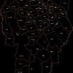
Map Curitiba Neighborhoods DWG Block for AutoCAD

Curitiba neighborhoods map
Drawing labels, details, and other text information extracted from the CAD file (Translated from Portuguese):
santana field, caimba, They are Miguel, will tattoo, There will be, industrial city, shallow capon, little hook, xaxim, Pinheirinho, site, surrounded, high, I’ll blow, industrial, august, City, butyrate, riviera, City, orleans, industrial, are, braz, there, santa, little farm, long field, new world, gate, would quit, village, izabel, cascatinha, Saint Ignatius, Mossunguê, happiness, seminar, big mouth, I do not know, meadow, happy view, parolin, beautiful, fanny, guaira, green water, hauer, old, meadow, guabirotuba, rebuffs, boat, center, francisco, retreat, mercy, are, good, civic, center, xv street, high, botanical, garden, King, Christ, cabral, glory, high, juvevê, hugo lange, pilarzinho, santa, little, lick, Saint John, lourenco, waterfall, are, covers, taboão, good view, barreirinha, bacacheri, uberaba, of, americas, garden, cashier, cashier, tarumã, capon, social, garden, imbuia, high street, tingling, holy candida, actuba, scale:
Raw text data extracted from CAD file:
| Language | Portuguese |
| Drawing Type | Block |
| Category | City Plans |
| Additional Screenshots |
 |
| File Type | dwg |
| Materials | |
| Measurement Units | |
| Footprint Area | |
| Building Features | Garden / Park |
| Tags | autocad, beabsicht, block, borough level, DWG, map, neighborhoods, political map, politische landkarte, proposed urban, road design, stadtplanung, straßenplanung, urban design, urban plan, zoning |


