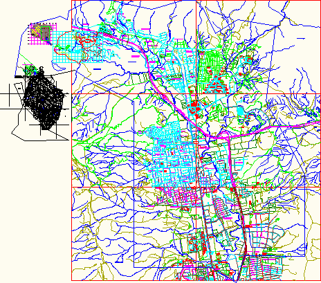
Map Of Naguanagua, Venezuela DWG Plan for AutoCAD

PLAN YEAR 2012 Naguanagua City, Carabobo Province
Drawing labels, details, and other text information extracted from the CAD file (Translated from Spanish):
route, coromoto, neighborhood, National road, Street, the light, neighborhood, avenue, from barbula, rural housing, Street, av. valmore rodriguez, Street, section, av. principal, route, deserve them, neighborhood, branch, section, branch, section, West, eastern route, route, East, rio cariaprima, west route, north route, mountain route, route of the sies, port valencia port hair, via center the cafe, barbula, urb. chaguaramal, malagon neighborhood, urb. The palm, urb. he, hills of girardot, neighborhood la savannah, neighborhood the line, from girardot, hills neighborhood, from girardot, hills neighborhood, urb. About Me, urb. the entrance, the entrance, retake river, qda. beautiful water, qda. girardot, Cerro Girardot, hill reel, via carabobo hospital, I closed the dam, rio cabriales, barbula, carabobo hospital, antituberculosis institute, psychiatric colony, av., Street, av., Street, av., Street, av., Street, democracy, neighborhood, guayabal, neighborhood, Caption, urb., retake river, av., main Street, port valencia port hair, Street, av. valmore rodriguez, engineering, faculty of, Street, av., main Street, av., c. February, democracy street, san rafael street, street to ravell, av., c. San Martin, c. lopez, c. s. Miguel, c. democracy, c. florida, January street, av. San Miguel, av. the triumph, av. the Orange trees, av. the cider, cjon giraldot, new street esparta, c. falcon, c. ponderosa, av. concord, calle ruiz pineda, street guzman white, av., Street, av. of July, av. college, street rivas davila, January street, av. andres e. White, street sucre, street chir, c. andres eloy blanco, av., Street, street mons. lucio esaa, av., Street, av., av. the samanes, street pastor, av. Valley, street jets, street the mangoes, c. falcon, av., av. breezes, av. Miranda, av. central, c. horizon, av. San Juan, av., traffic street, aeronautical street, Street, av. freedom, west neighborhood, urb. the, neighborhood union, neighborhood the cider, urb. the, urb. the coffee plantation, urb. orange grove, urb. orange grove, urb. Pinewood, barbula, elderly, asylum of, i.n.a.m., Street, av. Valencia, av., via carabobo hospital, School of Economics, motorway barbula guacara, port valencia port hair, barbula distributor, dist. naguanagua, port valencia port hair, av. the caracaros, guayabal street, c. mons. lucio esaa, av. college, av. Sucre, av. bolivar, av., av. cemetery, street pto. hair, street salon, girardot street, rio cabriales, environmental, health, School of Medicine, Education Faculty, sea breeze, urb., urb. the caracaros, guayabal, cabriales park, urb., urb. the guayabitos, urb. why naguanagua, urb. high valley, volcano hill, hill montemayor, river junction, doing the cumaca, rio san diego, disorder, San Diego, middle savanna neighborhood, monteserino hacienda, av. industrial, c. black first, c. silence, square, bolivar, c. tower, street tejeria, calle ricaurte, c. the cumaca, c. Valencia, street paez, June street, rio san diego, freeway guacara, and water, the polvero, new town, row the stump, he touched, qda. the oven, and water, rio guacara, cerro palmarejo, mujiquera row, qda. carabalis, qda. jelly, row the stump, tiger hill, urb. cute, neighborhood guere, green valley neighborhood, i.n.a.m., barracks, anzoategui, hip hop club of carabobo, association of farmers, shooting range, college
Raw text data extracted from CAD file:
| Language | Spanish |
| Drawing Type | Plan |
| Category | City Plans |
| Additional Screenshots |
 |
| File Type | dwg |
| Materials | Wood |
| Measurement Units | |
| Footprint Area | |
| Building Features | Car Parking Lot, Garden / Park |
| Tags | autocad, beabsicht, borough level, city, DWG, map, plan, political map, politische landkarte, proposed urban, province, road design, stadtplanung, straßenplanung, urban design, urban plan, Venezuela, year, zoning |


